28 Oct 2012 - Organ Pipes Circuit

Three of us (Angie, Bob, Di) set out to investigate this walk, which is listed as one of Tasmania's Great Short Walks. Hobart Walks [published by Hobart City Council] describes it as being of Moderate difficulty (i.e. some sections may be demanding for people with fitness/experience or without appropriate walking equipment), length about 9km, and taking about 4 hours.  We did the circuit in the anticlockwise direction described in this booklet, thinking that the steep section below the Chalet would be best experienced (by people like us with dodgy knees) going uphill rather than downhill.


We had a lovely spring day for it, and the mountain was buzzing with road cyclists, off road bikers, walkers, rock climbers, motor bikers and driving tourists.  We parked at the lower carpark at the Springs, and found the Great Short Walks sign just above the toilet block.  It was about 10.20am when we headed off from here on the Lenah Valley track, which was well formed, gently graded, nice fine gravel under foot, leading through lovely mountain bushland with occasional glimpses of the river down below.  There is a slight diversion to the right, through a childproof gate, to Sphinx Rock.  This is a must see - there are glorious panoramic views over greater Hobart and well down the river.

Back onto the Lenah Valley track, we passed Rock Cabin and skipped the minor diversion (downhill) to the right to see Lone Cabin.  We reached Junction Cabin, which now finds itself at the junction of at least six well used tracks.  The new North-South mountain bike track goes through this point, and seems to be very popular.


We had a fortifying snack and headed off at about 11.35am, up Hunter's track.  This track goes steeply up to Crocodile Rock, and then across several rock screes.

There are several more uphill sections before you meet the junction with Old Hobartians Track.  Here you turn left and head quite steeply up the hill, shortly reaching the Pinnacle Road near The Chalet (1000 m above sea level).  Pure mountain water is still available here through a handy tap next to the road.

We reached The Chalet at 12.50pm and had a very welcome lunch, sitting on the rock steps in the warm sun.  From there we took the Organ Pipes track, which leads slightly uphill but then is basically level around the east side of the mountain.  This track was surprisingly under maintained, with little effective drainage, meaning that most of the track was basically uneven rock.  Views down the mountain were fantastic.

Then we gaped in awe at the magnificent dolerite Organ Pipes.

  We saw a couple of climbing groups picking their way up the dolerite columns.

After the Organ Pipes this track began to pall a little. Luckily there were some lovely spring flowers to focus on, like Richea dracophylla:

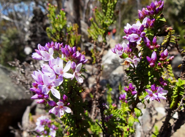
and this one, what is it called?


We finally reached the junction with the ZigZag track, and turned left down the Pinnacle track.  The final couple of hundred metres of the track was very well made, and we soon reached the site of the old Springs Hotel.  Only a couple of hundred metres more and we reached the cars at 3pm.

So the loop took us 4 hrs and 50 minutes, including snack and lunch stops.  We think taking it in the anti-clockwise direction was the right choice.  Stiff soled walking shoes or boots are essential for the rock-hopping.  A significantly shorter circuit, but including the key features of Sphinx Rock and the Organ Pipes, can be made by heading up the Sawmill Track not long after Sphinx Rock.  This shorter loop would probably take about 2 hours.

Angie and Di made an additional visit to see a spectacular Telopea truncata tree at the end of Bracken Lane (off Pillinger Drive) - incredibly large specimen with luscious flowers!

7 Oct 2012 - Growling Swallet and Junee Cave, Maydena

This is a lovely little duo of walks - the first to locate Growling Swallet, the place where clear fresh water draining off Mt Field West and Florentine Peak dives underground into the Junee-Florentine karst, and the second to Junee Cave, where the same water emerges at Maydena to become the Junee River, a tributary of the Tyenna River.  This cave system is the deepest in Australia, over 375m deep and several deep caves are over 10km long.

There were seven of us today - Di, Robert, Bob, Caroline, Angie, Julie and Lyn - on this expedition into the Florentine.  It was a lovely spring day, the first day of daylight saving.  We gathered at Di's place at 9.30am, where Robert obligingly made us all a coffee, before we set out before 10am.
We had to stop first at Mt Field National Park office, where Di signed on the dotted line to get a key (booked ahead) for access to F8 East forestry road. There is a $300 deposit for the key, and list of dire warnings like "There is no mobile phone coverage", and "The area features many hidden sink holes" just to reassure you.  We picked up a copy of the latest Mt Field park map, which we found very useful when navigating.

Directions:
Turning right back onto the Gordon River Rd (B61), drive west.   Just beyond Maydena there is a large road to the right with big tourist signs pointing to Styx Valley and the Big Tree.  This is the Florentine Rd, turn right.   This is a wide, well maintained forestry road.  Follow the road through the Lady Binney reserve, over the saddle by Tim Shea, and into the Florentine valley.  About half an hour after leaving Maydena you will find forestry roads F8 West and East.  Turn right into F8 East, where you'll need the key to get past the gate.  A four wheel drive would be useful here, but our i30 made it through! After 2 km of the narrow gravel, wet and in a couple of places, boggy, road, you come to the end of the road.   Here Robert identified the Tasmanian Froglet in a little pond, using his NPWS Tasmanian Frogs app!

Another reminder that you are on your own out here.

The walk is mostly level, and winds through beautiful myrtle and sassafras bush, with lots of mosses, lichens, ferns and plate fungus. There are slippery logs to clamber over and little bogs to splash through. 

Boots and gaiters are essential and a walking pole recommended.  We didn't notice any leeches though (yay).

Track markings are minimal, and failed us completely right at the end, where we got lost just near Growling Swallet. So, listen up! Not long after you can hear the rushing water over to the right, and just before you reach a small cavers' campsite with old fireplaces, there are two long very mossy trunks lying on the ground across the track.  These should be followed down to the right, where there is a slight scramble down the gully to the Growling Swallet.  This is a magical spot, beautiful and pristine.

 The Swallet entrance to the Florentine karst is awe inspiring and the limestone rock formations curious.

 Apparently at high water levels the cave growls as the waters surge downwards. The moss covered rocks and logs are very pretty.


Our diversion was to go beyond the campsite, along a trail someone had marked, to a fallen log upstream of the Swallet.  There is a lovely mossy bank here which would be ideal for a picnic.


We couldn't stop today, as Caroline had to get back to town early and we hadn't thought through the matter of the locked gate.

It's about 45 minutes walk to the Swallet, and about 30 minutes coming back (once you know the path!).

Caroline had recommended Junee Cave, and we decided to go there for a late lunch.  We drove back to Maydena and headed up the well signposted road to Junee Cave.  This is a well made gravel road, with a good parking area, which we reached at 2.30pm.  It is then about 200 metres walk to Junee Cave, where the waters which dived underground at various points such as Growling Swallet emerge out of the karst as the Junee River.

We finally had our picnic on a grassy bank of the Junee.

 Some of us had coffee on the way back, on the banks of the Tyenna at Westerway

It was a lovely day out!