March 2012 - Deep Hole beach, Ida Bay

Eight of us made up the party, arriving in our pooled cars at the Ida Bay railway station at about 10.30am on a perfect autumn day.   After securing our tickets for the return leg ($14 for an adult) on the historic Ida Bay Railway, we set off to follow firstly a four wheel drive track and then the rail lines to Deep Hole Beach.  Donnelly's Gates were curious - a well maintained front gate and garden, now  in the middle of nowhere.  

There was supposed to be a walking track from here which meandered around the track but that does not seem to exist any more.  So we walked along the tracks themselves.  This wasn't too hard, but meant more concentration on each step.  As we discovered afterwards, walking along the tracks also means picking up a fair bit of engine oil on the bottom of your trousers!  Luckily the oil came out OK following a good soak.  

The walk to Deep Hole bay is 7km long, and took us 1.5 hours.  We stopped briefly at the Cemetery at Ida Bay, where young members of the Tyler family (some early miners?) and the Jager family (early fisherfolk - later at the Dover Hotel Robert saw a picture of a boat they had built) are buried.  

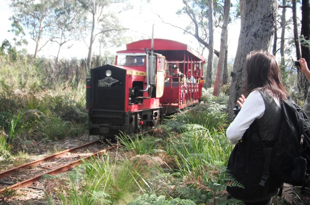
The train takes about 45 mins to get to Deep Hole, you have to keep an ear out for it and get out of the way! 
  

 Walking to the end of the lines out to the old jetty, Philip found a more secluded part of Deep Hole beach, where we had our lunches.  No-one was game for a swim, although the water looked lovely (there is a good safe shelf for kiddies). 

Some of us enjoyed a solitary stroll along the beautiful beach.
 
We caught the return leg of the 1.30 Ida Bay train, which left Deep Hole at about 2.40pm. What a luxury!

The views were better with a little elevation, and not having to watch our feet!

Back at Ida Bay railway station, we piled into our cars and headed back to Dover pub for a beer.  

Directions:
Leave Hobart at 9am.   Follow the Huon Highway (A6), turning off before Southport toward Hastings (C635) .  Head towards Lune River, then Ida Bay, park at the Railway station.  Buy train tickets from the cafe.  Walk from here on the four wheel drive track (near the railway crossing)  towards Deep Hole Bay/Southport Bluff. 

Option for next time:
Southport Lagoon and Southport Bluff: Take the railway to Deep Hole beach, then walk.  Easy grade, 2 hours return to Southport Lagoon and 2 to 3 hours return to Southport Bluff from Deep Hole. Round trip via Lagoon AND Bluff is 3 to 4 hours return. A profusion of flowering native plants may be seen in November and December.  

This would require taking the 9.30am train to Deep Hole Bay, arriving there about 10.15am.  Walk about 4 hours.  Catch the return leg of the 3.30pm train at 4.40pm. 

On the list for 2012

September - Growling Swallet, Maydena
October - Collins Bonnet, Mt Wellington OR Cathedral Rock via Kat's house

November - Shadow, Forgotten Lakes, Lake St Clair - 4hrs walk, views, need good weather December - Cape Raoul, Tas Peninsula - great views, seals, possible S2H yacht sightings

More good ideas:
Maria Island
Mt Wedge
Labillardiere Peninsula  - time this for spring flowers?
Schnells Ridge
Shipstern Bluff, Tasman Peninsula - 4hr return 
Lake Skinner - rec by Caroline 
North, overnighter - suggested by Lyn

February 2012 - Pelverata Falls

This walk slipped into early March because of unseasonally high temperatures on the weekend we had originally scheduled this walk.

Pelverata Falls:   A very tall waterfall in the Snug Tiers (approximately 114 metre drop), a 2-3 hour return walk on a good track to a viewing platform. 
This is what it probably looks like in Spring after sustained rains!  
The walk took us an hour each way, although Robert complained that we didn't make enough stops to admire the views.

Directions:
Take the Southern Outlet to the Sandfly turnoff.  Turn left, and then turn right almost immediately onto Pelverata Road.  (This might be a good spot to meet up).
Drive to Pelverata, which is a further 11km.  Just past the township, turn left onto Crosswells Rd (well signposted), go 1km up the hill to a clearly marked parking area.  You can also approach from the south, from below Huonville, although this road is mostly gravel.

The walk :
Follow the sign along a pretty leaf littered trail for approx 0.5km to where it joins up with a vehicle-wide track, Vincents Track.  


This follows a farm perimeter east before turning sharply right (sign posted "Falls"), and heading south-east through thicker bush.  The track has a steady but gentle climb.  The last 15 minutes are steeper and rockier, making me wish I had worn proper walking boots/shoes.  The walk  curves slightly left into sight of the falls.  There is a new very solid viewing platform (no seats or tables) to stop and enjoy the falls and the little valley where Pelverata and Slippery Creeks meet.  


Scrambling down to the creek seems to be discouraged these days.
The walk back is a nice gentle downwards amble. 

January 2012 - old Kaoota railtrack

This is an easy walk along the line of the old railway track of the now defunct coalmines of Kaoota, just south of Sandfly.  Caroline, Bob, Di, Robert and Lyn were the intrepid walkers on this very hot day.  We did a car shuffle, leaving one car at the Kaoota end and returning to start the walk at the Nierinna end.  We were lucky to miss being caught up in the Targa Tasmania route, which had used the Pelverata Road that morning and had finished just before we arrived. 

The walking track was level, all under light bush cover, and took about an hour and a half.

December 2011 - Cape Queen Elizabeth, Bruny

This was a nice walk based around a picnic at Cape Queen Elizabeth, organised by Caroline.  We were a big party:  Caroline, James, Bob, Catherine, Peter, Di, Robert, Kat, Philip, Lyn, Angie.  It was a pretty hot and windy day, and we were surprised to find there was no cleared or sheltered picnic spot on the Cape Queen Elizabeth headland, so we returned into the light bush below the headland to share a yummy gourmet spread amongst the trees.
  
4 hours return (Mars Bluff is 2 hrs return)
The walk commences at a 4WD track just north of the Bruny Island International Airport(!).

Likely ferries leave at Kettering at 9.30am and 11.05am and return from Bruny at 4.30pm and 5.30pm (Its not a long drive from the ferry terminal to the start of the walk). Would be financially best to car pool at least across on the ferry. On this trip we took the 11.05am and 5.30pm ferries.  Robert took the Easy Rider option.
  
The walk passes Big Lagoon, a waterbird haven in the Bruny Island Neck Game Reserve, and leads directly to Neck Beach.


Neck Beach, Miles Beach and a little secluded beach in between are all pretty beaches of white sands and few people. 


We found that the beach connection around Mars Bluff to Moorina Bay is only available at the lowest point of the tides (check the tide tables!).  Even near the low tide it is a minor cliff scramble or a swim to get around.  We weren't lucky enough on arrival and had to return up the track a little to take the path over Mars Bluff. 


We descended onto Miles Beach and headed up the next headland of Cape Queen Elizabeth. On this headland the walking was easy and mostly under light bush cover.
On the way back we were close to low tide and we had a slightly scary climb around the rocks (anything to avoid climbing over Mars Bluff again!).  Bob took the wet option (on purpose). I don't think I was the only one to be a bit weary after this long-ish day out in the hot sun.

September 2011 - Scotland

Robert and I found a couple of opportunities for short walks on our motorhome tour of Scotland.

At Loch Ness we enjoyed a saunter on the eastern side of the lake and then another breezy walk as we approached our first taste of the highlands and the heather.  This view is actually from the bottom of the lake, looking northwards.


Near Loch Lomond we came upon Queen Elizabeth Park.  Here, at Loch Katrine, Sir Walter Scott penned "The Lady of the Lake".  We enjoyed a pleasant (flat) walk around the lake's edge and gave the touristy lake cruise a miss.


April 2011 - Swanwick

Robert, Di, Kerrie and Richard -

February 2011 - MONA

Does a four hour arts crawl around MONA count?


January 2011 - Boronia Beach

Di, Robert, Caroline, Bob, Carol, Kat and Philip discovered secluded little Boronia Beach just on the north side of Blackmans Bay.  Then we enjoyed a sunny clifftop walk to Kingston Beach and back.


We checked out the site of an old blowhole at the north end of Blackmans Bay.  Then we undid all our good work with a barbie at Bob's :)

October 2010 - Piha Beach

Di, Robert and Harry encounter black sands and volcanic outcrops, New Zealand.


Robert and I climbed up Lion Rock, because it was there.  Dad is probably one of those specks on the beach below.

August 2010 - Buckland Gorge


We were lucky that Caroline could arrange for Stuart Whitney to be our trusty guide on Saturday.  Without him we would definitely not have found and stayed on the track.  Stuart, James, Caroline, Robert and I had a good walk, a little tricky at time, with parts of the track affected by the recent downpours.  There were some steep slippery sections but there were no accidents.   The Gorge is beautiful and the hidden sandstone rock caves swirl with colour like the ones on Maria Island.  Stuart says that is because this rock formation extends through out to Maria.     


The gorge is a refuge for wombats, devils, birds and other wildlife.  We had lunch on a clifftop overlooking the river far below, and then took the short way out as it looked like rain was imminent (luckily it stayed dry for us!).  We made some notes on the map below that I located on the net, and I think with this info, we could do the walk again on our own.  We had a refreshing beer at the Olde Buckland Inn, and then rounded out the day with some culture(!) by visiting the historic St John the Baptist church to see its medieval Eastern window.  


Directions:
Opposite the church in Buckland, take the turnoff heading north towards Oatlands. About 12 km along, the Swanport State Forest commences.  Here the fields cease at fence lines on either side of the road.  Park here and take the 4WD track to the east, with the field fence line on your right hand side.   
After about 25 minutes there is a turn to the left.   Shortly after, you must find a turn to the right to take you to the edge of the Gorge.  This would be very easy to miss - look for coloured survey tags.  The track descends into the Gorge and takes you along the left side, past caves carved out of the colourful sandstone, similar to the Painted Cliffs found on Maria Island.  The track is quite steep in places and great care needs to be taken not to slip.  The track descends to the Bluff River and then ascends the cliff again.  There is a fine headland which gives great views over the Gorge, a good place to stop for a snack.
From here it is a very short distance back to the west to pick up the 4WD/logging track which will get you back to the track along the fenceline in 15 minutes.  


July 2010 - Crescent Beach

Tasman Peninsula - Di, Robert, Lyn, Kat, Philip, Bob, Caroline, James, Angie.
This was a fresh winter's day, with the prospect of spectacular isolated beaches. We parked at the lookout above Remarkable Cave and headed east across the headlands. The walking was easy and the views terrific. 
It was James' first bush walk.

This is the approach coming down towards Crescent Beach:

How lucky we are in Tasmania!

The beach was perfectly formed and all ours.  We perched on the rocks at the far end for lunch, and then exitted the beach over the dunes.
This wasn't as easy as it sounds!


On the way home we stopped for coffee and cake at the cafe opposite the entrance to Port Arthur, the one that the owners tried to sell by raffle.  I wonder how that ended up.

Mark has some lovely photos from his walk to Crescent Beach in Feb 2012.

May 2010 - Long Reef

I took a long walk up Sydney's northern beaches - Curl Curl, Dee Why, Long Reef, and back again!

March 2010 - Mt Field East

Di, Kat, Philip and Bob set out to Mt Field on a beautiful summer's day.  Unfortunately Lyn had the flu and couldn't come that day.

We parked up the Lake Dobson Road at the marked carpark, and walked to Seager's Lookout, a rocky outcrop looking back across to the east.

 There were a lot of rocks!  Perhaps someone else had been there before us.


Then on across the mountain scree, climbing up past Lake Fenton.


The view from the top of Mt Field East, where we stopped for our lunch, was fantastic.  Great views across to the west

Then we scrambled back down, taking a looping circuit down the cooler side of the mountain.  The clean,  clear and cool waters of little Lake Rayner were very welcome.

We worked back down and across the hillside to the mountain road, and the tired ones rested while Philip walked up the road to collect the car - thanks Philip!
A beer or two at the National Park pub was then in order, we thought..

February 2010 - Mt Hartz

On a fantastic clear and hot summer's day, Lyn and Di enjoyed the clear air and spectacular views from Mt Hartz.

Directions:
Travel to Geeveston, turn to the west along Arve Rd towards Tahune Airwalk.  Shortly after passing the Arve River picnic area, there is a signposted gravel road to the left leading uphill to Hartz Mt.  Care is needed on the road, with sharp corners and some rough patches.  Drive to the end and park in the recently rebuilt carpark.  There is a modern visitor/registration shelter here and composting toilets.
 The track is well maintained and includes duckboarding in the early flatter sections.  The rugged windblown mountain plants are pristine and beautiful.  The track curves towards Lake Esperance and a very short side trip to this lake is lovely.  The track continues soutwards to Ladies Tarn, before rising and turning westwards again to climb towards Hartz Pass. 
The right hand track at Hartz Pass leads to Hartz Lake.  Continue to the left and up Mt Hartz, with lots of rockhopping and a breathtaking steep ascent.  The reward is fantastic views into the S and SW.

Excellent detailed info and instructions can be found at Mark's Bush Blog.

January 2010 - Cape Raoul

Lyn and Di each made a long list of New Year's Resolutions!   Di's included a determination to do at least one bushwalk each month.  So we started, by enjoying a beautiful (hot) summer's day on peaceful Cape Raoul.

Directions:
Nine kilometres past Port Arthur there is a turn left along Stormlea Road.  Another 9 kilometres further on (gravel road) is a parking area for the Cape Raoul, Shipstern Bluff and Tunnel Bay walks. 

You start the walking track at the entrance to the Raoul Bay Retreat accommodation.   The track winds its way through some scrub before entering larger bush. You cross a fallen tree bridge over a little creek , then hike up to a marked junction in the track. Take the left fork for Cape Raoul.