26 Sept 2012 - Summit Loop, Knocklofty

Today was a glorious Spring morning, and the bush fringes of the mountain park were irrestible.  This is my favourite local walk, a one hour circuit of Knocklofty via the Summit Loop track.  It is 4.5 km long.


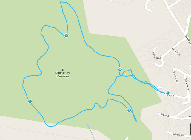
I usually access this walk from the top of Kirby Court. Unfortunately the usual parking area up next to the old Pacific Vista hotel is closed off at present (for revegetation, I think) so if arriving by car you need to park at the turn around area at the end of Kirby Court.  Walk up what looks like the driveway of the old hotel, walk through the closed off car park, veer left up the bush track.

I like to do this loop clockwise, starting by turning hard left where the bush track emerges into a grassland area, and strolling through the meadow on the left of the frogponds.  Turn left at the level track, heading southwards and towards the Knocklofty lookout.  Today the wattles were a riot of spring blossom. 


Just past here is the historic spot where Glover stood to paint his famous view down the Derwent.

The track here is level and very well maintained, both by the Council and by the loyal and hard working volunteers of the group Friends of Knocklofty.  The track can be accessed near here from the top of Poets Rd.

The view from Knocklofty Lookout is panoramic and just stunning on a clear day.  The track can be accessed near here from the top of Forest Road.


From here, backtrack slightly and take the track to the left and up the hill.  The next 20 minutes are fairly steep and steady, with views towards the mountain as you come around the back of Knocklofty.  Finally you reach the top of hill, the halfway mark of the loop.  This is where the track from Mt Stuart meets the Summit Loop. Turn right.

It's great to be at the top!  Here the dry schlerophyll bush thins out a little and the sunshine washes through.  You can often see wallabies bouncing around up here.

The reward for the 20 minutes uphill slog is the relaxing downhill meander through pretty bush.  Halfway down, on the right hand side, is an attractive wood bench seat - a great spot for a picnic.


While enjoying a drink or a snack, you can enjoy a great view over West Hobart towards the bridge.

The track continues downhill and then around a level closure of the Loop track.  I like to stop and listen for frogs at the Frog Dam just before exitting the park.

UPDATE January 2015:
The downhill section has been rebuilt to remove steps.

Here's another route to access the Summit Loop, from the carpark at the top of Poets Rd:

1 Sept 2012 - Three Thumbs, Orford

The first day of Spring!  It was a lovely day, sun shining and all seeming right with the world.  Six of us set out (Di, Robert, Catherine, Peter, Kat and Philip).   We approached the Three Thumbs walk from the Spring Bay end, because we knew  that the shorter approach (via Copping) was unavailable.  Robertson's Bridge (over Sandspit River) has been washed out (again) and the last we had heard on the news was that no-one was volunteering to rebuild it.  We left town at 10am, and it took an hour and 20 mins to get to the start of the walk. 

Driving directions: 
Tasman Highway (A3) from Sorell to Orford. Turn right just at the bridge onto Charles St (C320) (toward Wielangta Rd). Before 1 km along, where the road is signed as becoming Rheban Rd, turn right onto Wielangta Rd. This turnoff is badly signposted! There is also  a disconcerting "detour" sign not a long away along the road. After 4 km, turn right onto a forestry road - there is a good sign here to the Three Thumbs picnic area. Drive uphill to the start of the Three Thumbs track (well marked). This is at a big bend in the road (the road leads further on to the Thumbs picnic area).  Park here. At the picnic area there is a shelter (and that's about all), but good views to be had over the coast to Maria Island. 

The walk: 
Suits: Competent (fit, some steep sections, footing variable, some wayfinding required)    
Time: 2 hours return            Length: 4km 
After an initial steep start, the track climbs gently to the ridge line of  the Three Thumbs. Then there is a signposted option to take the Forest Walk to the left. We took the right fork, which follows the ridge line along over a few bumps (the Thumbs) to the highest point at 549 metres. 

 The track was generally well formed and marked with cairns and marking tape, going through dry eucalyptus forest.  There is no water available along the ridge.   At the Three Thumbs peak there is a trig station and some nice flat rocks to sun yourself on.  

Unfortunately the trees around the summit have grown and tend to obscure the view (dammit). 

Robert got the prize for the best gourmet picnic today.


On the way back, we took the Forest Walk option to the right, making a loop of the walk. This passed to the west side of Thumb number 2, dipping down into a moister temperate rainforest microclimate - lots of pepperberry, blechnum ferns and damp logs.  We heard lots of birds but were not good at identifying them!  The track was fairly overgrown, with some fallen trees providing obstacles to slide around. No leeches though :)   Despite the steep descent into the valley the ascent back to the main Thumbs track was surprisingly easy.  And the Forest Walk route took the same amount of time as the ridgeline walk.

 We had planned to visit the Scorchers by the River Pizza Cafe in Orford for drinks and snacks after the walk. Unfortunately it was closed for the August quiet season and we had to make do with the with cafe on the corner, where the sporting themed decor was decidedly odd.