Oct 2017 - Cape Raoul

It has been a long time between posts, fellow walkers!  We've not been entirely inactive, there have been some group walks held in the last six months, but we've been too busy to share the details.  This month Lyn organised a return to Cape Raoul - we last visited here over seven years ago in January 2010, so we were interested to see what had changed.  The track is currently being improved so that Cape Raoul can be added to the excellent Three Capes walk.

There were seven of us - Lyn, Di, Robert, Bob, Kat, Philip and Angie - setting out on a perfect spring day.  We left Hobart at 8.30am, rendezvous-ing at about 10am at the Nubeena Bakery for coffee.   The bakery was pretty basic and Angie was very unimpressed with her muffin, but the coffee was OK.  The nearby Lucky Ducks cafe looked more interesting - next time! 

Not far out of Nubeena we turned right into Stormlea Road and were soon in the carpark at the beginning of the walk.  The carpark has been expanded since we were last here (we've been to Shipstern Bluff a couple of times since then - 2013 and 2016), and a handy dunny in a field has been added.  These walks are included in Tassie's 60 Great Short Walks and Shipstern Bluff in particular gets a lot of visitors.

Keen to get onto the track!


Lyn dutifully registered our group in the walkers' book and we set off at about 10.50am.  The track workers have completed about 75 percent of the planned improvements and the walking is already a lot easier.  Compacted gravel paths with attractive stone retaining borders, and better graded inclines, make the path more comfortable.  There is a sturdy timber bridge where we used to have to teeter over a slippery log!  Now we can enjoy the scenery instead of having to concentrate on every step.  Soon walkers here won't need boots any more, as walking shoes will be quite adequate.

Duckboards added to sections prone to mud

Shortly after we reached the clifftop we came upon two men creating a couple of lookouts.

New lookouts under construction


and enjoyed our first glimpses of the Cape:
So that's where we're going!


The track along the clifftop was very pretty, through dry coastal bushland, and it was soon clear that there would be a good display of spring flowers.


Then we were heading down the incline, through sheltered and still slightly damp woodland, toward the exposed plateau of the headland.


Looking back towards Shipstern Bluff


Near the shallow lake we passed the workers' tent and tools of trade.  From this windswept plateau we were quite near the point of the Cape:

The cliffs are fabulous


After 2h 15 mins walking, we found some rocks with a view on the point of the Cape, and sat down to devour our very welcome lunches.  Our views to the south were great - while munching we saw ships steaming towards the Derwent, fur seals swimming, and albatross and martins flying.


After about half an hour, we got going again.  Doubling back, we visited the new lookout just to the north over the seal colony.  We could hear the fur seals barking below, it was lovely.


It felt like a long walk back, there being a fair bit of uphill in this direction, so there was plenty of time for talking.


By the final downhill stretch to the carpark we were a bit tuckered out (it was 14 km after all!), so conversation gave way to amiable time and space for quiet reflection.

We got back to our cars at 4.05pm, making our walk 5 hours 15 mins, a good effort we thought, given we are a bit out of practice!


...

April 2017 - Bicentennial Path, Mt Nelson

On a beautifully sunny Autumn day, ten of us gathered at the top of Lambert Ave, Sandy Bay at 11am.  We last walked the Bicentennial trail as a group in June 2012, so we thought it was time to take another look.  The combination of easy access, small amount of time required, sunny day, and the lure of a cafe at the top for lunch, brought out the gang in force.

It was a pleasant walk up the hill (naturally, it's all uphill to the top of Mt Nelson!), through well managed bushland.  There were a lot of other friendly walkers called to the track by the sunny weather, and some of us ran into good mates (it must be Hobart).  The well-marked paths were dry, the sky a solid blue, and the views pretty. 

It was good to be able to natter as we walked, catching up with what our friends have been up to since we last saw them.  And for some of us to share our imminent travel plans to escape a little of the southern winter.

We reached the cafe at the top in an hour, glowing with our effort(!).  Our booked table (easily done via FB Messenger), was waiting for us, nicely laid with linen cloths and glasses at the ready.  What had been a cafe on our last visit is now the licensed Signal Station Brasserie, with (as we discovered) a concomitant markup in presentation and prices.  Think: entree size dishes for main course prices.  My tip: I reckon the seafood chowder was the best value. 

As we were starting to seriously cool down, we didn't linger after eating, but headed back out into the sunshine.

Today's Top Ten


It was an easy downhill return along the same track.


We got back to our cars and bikes in Lambert Ave at about 2.15pm. A nice day out with old friends.


February 2017 - Ralphs Falls

Our official walk for February transmogrified into a bike ride to MONA (Angie, Robert and Di) to enjoy some music and the market, and then a performance of Music for a Warming Planet at Moonah Arts Centre (Angie, Robert, Di and George).  So as a substitute, here is a description of a walk by Di and Robert to Ralphs Falls earlier in that month.

Ralphs Falls is one of Tassie's Great Short Walks and is also well described in Thomas and Close's excellent 100 Walks in Tasmania.  It is accessible by gravel road either from Ringarooma or from Pyengana.

Thanks to 100 Walks in Tasmania
We fortified with coffee and stocked up on cheese at Pyengana, where we also got reassurance from a couple of locals that the gravel road would be navigable by Wanda. Coming from this direction, the turnoff is to the right at the foot of the road up to St Columba Falls.

Our first discovery was this sturdy old wooden bridge, over the beautifully clear New River, with a potential cosy campsite nearby.


New River

The gravel road is minor (one vehicle wide only) but in reasonable condition.  Drivers seemed to be pretty careful and courteous, which was nice.

Mount Victoria Road is used by the logging industry, but there was no logging on the day we went through.  There are lots of logging access roads, large and small.  We first got confused on the brow of a hill where a tree sported a hand painted sign to Ralphs Falls (great) but you couldn't tell which road it was referring to (not great).  We followed our noses to the right and then a little further on we ignored another tempting possibility to the right. Thankfully this turned out OK.

The carpark for Ralphs Falls is large and very well set up, with a toilet block, covered picnic tables and barbecue.


We set off at 1.20pm, walking the loop as described in the map above, clockwise, straight into a pretty, dense nothofagus forest.  We took the short diversion to the left to the lookout, and found out that it gives views over the sleepy valley and back to the lovely Ralphs Falls.  In fact this is the only way to (safely) see the Falls.  Sadly, vandals have destroyed the binocular telescope which had been thoughtfully provided by the locals!


Ralphs Falls is a sinuous thread of water falling 100 metres along a curving slash in the dolerite.

 
There are no signs inviting you to walk the full loop.  My theory is that this is because there is no fencing when you get to the vertiginous cliffs above the falls, and National Parks are worried about public liability claims.  What a shame that things have come to this.  Anyhow the walk is easy, attractive and interesting, from a sheltering tea tree forest to a duckboarded section over montane buttongrass plain.  With stops for photos, and another short diversion to look at Cash's Gorge, we got back to the carpark at 2.40pm.

We trundled on towards Ringarooma, mostly downhill at this stage, stopping to admire the old hand made drystone retaining walls constructed in the 1920's and still reliably holding up the road.  It was time for a picnic lunch in fact!


March 2017 - Meander Falls

Meander Falls is one of the highest falls that tumble down from the Great Western Tiers.  It is also one of Tassie's 60 Great Short Walks, and it was time for us to check it out.   National Parks describe it as  "A full day’s walk that gets you away from the more popular areas and into the Tasmanian Wilderness World Heritage Area".  They rate it as 4.5 - 6 hours return, and Grade 3.

As it is about a three hour drive from Hobart to Meander, we decided an overnight stay was in order.  Di and Robert opted to take Wanda for a cosy home away from home, and George decided to visit Deloraine, staying at the Deloraine Hotel.  He reported that the rooms were comfortable, the bathrooms recently renovated, and it was a bargain price.


Getting there: finding Meander village is pretty straightforward.  However there is no signage as you leave the Meander village centre, so here are some important notes:  wave at the nice old lady standing on her verandah (we did, twice);  when the sealed road runs out, keep going straight ahead (don't turn left towards the dam);  after the Huntsman's Lake picnic ground, follow your nose and veer right on the new unsealed but smooth road.  Once you're in the pretty myrtle forest, there is bright new signage to go with the new roads and the two new bridges.  There were massive floods here several years ago, and the two old bridges and the old picnic area were washed away.  The new infrastructure is very impressive. The old picnic area has not been rebuilt but it was still a good spot for a self contained motorhome to camp.

We had arranged to meet at the Meander Falls carpark at 8.30am. George was early and (ahem) Di and Robert were late!  There was no mobile phone coverage up in that area, so it was lucky that our paths crossed as George was driving away thinking about a game of golf instead. We hit the trail at 9.15am.

Our first impressions of the trail were fabulous, it was lovely temperate rainforest, with myrtles, sassafras, leatherwoods, mountain pepper, ferns, even King Billy pines.  It had rained a little the day before so the trees happily dropped their morning dew onto us.


The track was damp and the rocks and roots a bit slippery, but conditions were pretty good as befitting the time of the year. The trail was simple, with little obvious grooming and only occasional additions of steps or bridges, but seemed well looked after.  There were a few diversions around treefalls, so the leader had to be sharp at wayfinding and spotting the next triangle pointer or surveyor's tape amongst the trees.


It was quite Tolkienesque - we half expected to see hobbits and wizards stepping along in front of us over the the leaf littered rocks and tangled tree roots.

A resident

With the river babbling away on our right, it was heavenly.  The forest was pretty moist, even though it was late summer.  We had a lovely sunny day, so the sun was dappling through the trees, and the humidity of the forest was pretty high.


We discovered that the path to the Falls is all uphill, with the gradients fairly gentle for the first third of the way, then getting steeper... 

Spot the hobbitses

A snack break at the two hour mark was a good idea.  A pool here, at the base of the Falls, would be a good spot for a swim on a hot summer's day.


The last third of the trail seemed to lead us away from the river and up a very steep pinch, which seemed both odd and unfair!?!  We gritted our teeth and pushed on.

Heritage signs!

Finally!  We reached the lookout to the Falls at 12.20pm, just about at our physical limits, and congratulated ourselves and our 50 and 60 year old bodies for making it.  There seems to be a track leading onwards and upwards into the Tiers, no thanks!

The Falls were in full flow and powerful, a lovely sight. The sun was shining, it was just perfect.


After a light but yummy picnic lunch and a bit of steaming off in the sun, we set off on the return trail at 12.55pm.  The downhill going, over the afore-mentioned rocks and roots, required good concentration, and our knees and ankles were put to the test.

We filled our water bottles at a rushing creek on the way down - George described the taste as nectar.


One for Bob!

It was a great relief to return to the lower level of gentle grades, soft leaf litter paths and tinkling river rapids off to the side. We made it back to the carpark at 3.30pm (total walk time, including lunch stop - 6h 15min), well pleased with ourselves and very glad that we had seen the beautiful track and Meander Falls.  There are a number of other tracks in that area that might bear investigation at another time....


January 2017 - John Smith's Monument, Mount Wellington

Apart from a miscalculation about the time this walk would take, it was a lovely day on the Mountain for us - Di, Robert and George.  About the time: TasTrails had this walk pegged at 2 hours, when we got to the start of the track the sign suggested 1hr 30 mins each way, and we actually took 3 hrs 40 mins (including a 15 minute stop at the monument).  Hmmm.  I think we need to be more careful these days about estimating how long walks will take us (or get a lot fitter!).

The top of Mount Wellington was a little cool at 10am when we set off, but the clouds burnt off and we warmed up as we walked, so we were quickly removing layers.  Soon we were bathed in sunshine. 

The turnoff to Smith's Monument walk was only a short way along, and would be easy to miss - luckily a helpful person has scratched a directional arrow onto the sign to make it clear that this is where we turn off!


Sooner than expected (i.e. immediately) the track becomes rough and rocky, marked by snow poles. Stiff-soled boots are a prerequisite for rockhopping all along this track, also gaiters as the low growing scrub is prickly!  We were all glad we had walking poles too.

There were many flowers out, which was lovely, and the dolerite columns were spectacular.

The grandeur of the rocks

 And check out that interesting outcrop on the right, as seen by Mark Clemens in about 1985:

Mark Clemens, 1985
The views over the Derwent and into the west were terrific.

Looking over the Derwent

 
Enjoying the view


Looking to the west


Turn left for the Rocking Stone


Rocks everywhere, on the roof of the world

 Skinks were lazing on rocks all over the place, even on the path!

A walker's self portrait

It was actually a bit muddy in parts, as both George and Robert discovered at the cost of a wet foot each!   Many of the little pools were busy with tadpoles.


It was wetter than we expected up on the plateau

The trail dropped down from the top plateau into a rocky field.


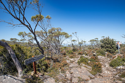
We found the new sign to Smith's Monument:

George shows the way


and then the old sign.


The track now passes through a sketchy cover of windblown E. coccifera, and the rocks get larger.  Thankfully the snow poles continue here, as it would be difficult to find the rock cairns alone amongst the bushes. 


It is a bit odd to come across this shrouded object in the middle of nowhere:

Booh!

until you realise that this is it!


We had a short snack break - the march flies were a bit annoying - and set off on the return trek towards the Pinnacle.  This was mostly uphill but not too difficult. 

We were impressed with how many other walkers were on the tracks, and the Pinnacle was crowded with both locals and tourists - taking photos from the summit, enjoying the views, walking, and riding.  The Mountain is a wonderful natural asset for all of us, we must keep it safe.