Peter Murrell Reserves, Blackmans Bay, Oct 2013 and March 2014

Our March 2014 walk was to be an easy one, as we have quite got out of the habit of walking recently, what with the distractions of Christmas, holidays and unexpected hospital stays (gosh, are we getting old or something?).  So Di, Robert and Julie eased into the day with a cappuccino before heading to Blackmans Bay to pick Bob up.  From there, only a couple of blocks away, we rendezvous'ed with Austin in the little carpark off Burwood Drive.

We walked northwards and anti-clockwise around the outsides of the Peter Murrell Conservation Area, along fire trails:

Disappointingly, there were not many wildflowers out.  When I did this walk  in early October last year, with Angie, Heather and Joan,

we saw lots of:
Slender sun orchid

lots of little flowers
springing up in the mowed verges of the park.  Early March is not a good time for these exquisite flowers.  Also we found out that a bushfire prevention burn had got out of control recently, and a large part of the Conservation Area was pretty black.

Still, we had a nice walk, catching up on what we have all been up to lately, and the weather was fine.   We visited Penrhyn Pond, which has ducks, a shelter shed and access for people in wheelchairs to do some fishing. 


Then we headed south along the horse riding trail, encountering some forbidding looking geese:


and had to do a little scrambling to get onto the dam wall of Heron Pond. 


Heron Pond is very pretty, with ducks and huge blackwoods and white gums to admire.


We walked south along the Coffee Creek Fire Trail, then turned into the Peter Murrell State Reserve, which is more protected than the Conservation Area.  Bikes are not permitted on the Nature Trail, however we could see recent signs of them on the track and everyone ignores the badly designed "bike deterring" chicanes.   

In October, Heather took us along the right hand leg of the Nature Trail, which was rather lovely.  This time, we took the left hand leg, which turned out to be a mistake.  It was a bit degraded, there had been fire there in the past and the trees were taking their time to come back.  Perhaps it is nicer in the spring.

Still there were some pretty flowers to admire, including Trigger plants, and this one:

 We got back to the carpark before midday, so the loop we did took about 1 hour and 40 minutes.  And it was just the right timing to visit the Beach cafe at Blackmans Bay for lunch!  


Fluted Cape, Bruny Island, October 2013

I think we've all got a bit out of the habit of the monthly walk!  So there were just five of us for this walk, on the "Show Day long weekend".  Robert and Di were already on Bruny Island, travelling around in Wanda - read about that here.  Lyn, Sophie and Brett caught the 9.30am ferry from Kettering, and stopped en route to pick up cheese and bread from the Bruny Island Cheese Factory.   They arrived about 10.40am at the ample carpark at the far end of the historic Adventure Bay beach.  This location is called Cookville and is apparently where the first apple trees were planted in Tasmania by botanists Nelson and Brown, who arrived with William Bligh.


The Fluted Cape walk is 6.5 km long, protected within the South Bruny National Park, and is well described in the current edition of  "100 Walks in Tasmania":

The authors recommend doing the loop counterclockwise, and we found that to be pretty sensible - this way you have an easier slope going upwards, and the steeper sections are on the descent).  It's also on the list of Tasmania's Great Short Walks:

The walk now commences from the beach, so from the carpark you take the track down to the beach, then walk along to the right and look out at the end of the beach for where the track steps up into the bush.

The walk is quoted as taking 2.5 hours, assuming minimal breaks.  We set off at about 10.50am and had a pleasant walk up the hill.  It wasn't steep enough to stop us chatting all the way!  The bush was pretty, open eucalypt forest, typical of the east coast/island vegetation.  When we got to the 250m high cliffs, the views towards the Tasman Peninsula were magnificent.

We looked down at a couple of Bruny Island Adventure Tour boats nosing into the bays, and then saw a pod of whales, several adults and young ones, frolicking under the cliffs!  How beautiful.  I was glad I had my binoculars!

The walk downwards along the clifftop was quite steep, and has recently been moved inwards, away from the edge, which is a good idea.  The casuarina needles and seedpods are thick on the ground, making the track quite slippery.  The views on the way down are beautiful, over the rugged fluted dolerite cliffs and pristine waters.   The rich kelp forests are very healthy, and the sealife must be incredible in there.

The pebbly beach at the Gulch might be a good spot to stop for lunch.  We kept going and reached a cleared area close to Grass Point, the site of an old whaling station, at about 1pm.  There were a few bones still in the undergrowth.

Our picnic lunch was yummy, including a few Bruny Island gourmet treats.  After about 20 minutes, the walk back from here was level and easywalking, taking about half an hour to get back to the beach.

We got back to the carpark before 2pm, so this walk took us a total of 3 hours, including our lunch stop.  It was a very pleasant loop walk, well recommended!

We were a little worried about possible huge queues to get on the ferry given it was the end of the "long" weekend, so Robert and I headed to Robertsons Point with Wanda, and got there well ahead of the 3.15pm sailing.  Lyn took Sophie and Brett for a look around Dennes Point, to remember old holidays and possibly plan another one.


Snug Falls and Coningham Cliffs, July 2013

This Sunday, Bob organised a duo of short walks, with a beach picnic in the middle. What a good idea. First we did the Snug Falls walk.  Caroline, Robert, Julie, Wayne and I met Bob at the carpark for the Snug Falls at 10am.   It was a mild, overcast day, and the track was dry, so it was an easy walk down the hill, only 25 minutes.

There were some lovely mini caves in the rocks, and hidey holes in tree trunks, which kids would love.

The falls were very nice.  

The rocks were quite slippery, and it was Robert who had a fall today, getting his feet wet in the freezing creek.  Bob and Wayne ran into a friend and enjoyed catching up (it must be Tasmania!).  But it was a bit cool in the shadowed valley, so we didn't stay very long. 

The walk back up the hill was easy, and seemed actually shorter than the trip down, but it was the same time of 25 minutes.  Back in the cars, we headed to nearby Coningham Beach, where we spread our picnic contributions out to share.  Wayne and Caroline had both bought chicken and brie quiches(!), and we agreed that the one from the Bellerive Food Store was the better one.  Robert and Julie had both made muffins(!), although Robert's muffins were savoury and Julie's were deliciously sweet (coconut and lime). Bob discovered his inner gourmet, with dukkah, balsamic and fresh bread.


 Feeling rested and refreshed, we set off from there along the beach, and were excited to see a sea eagle soaring above.

 At the end of the beach, near the colourful boatsheds, steps led up to the cliffside path.

The cliff top walk was easy going, with great views now and then over the Derwent.  The first part has been renovated recently, and moved back from the edge.  There are seemingly endless warning signs.  Clearly if you disobey the signs and approach the cliff top, and have an accident, you are a complete idiot and no-one should bother trying to rescue you.  And it's not the Council or government's fault.


Bob captured this interesting fungus:
It's called "Yellow Brain" from the Tremella mesenterica group.  The colour deepens to orange as it ages and dies.

There are several cute interpretive signs, created by kids from the local school.


The track descends to a small beach, which looks most readily accessible by boat.


It then climbs up to the clifftop again, and meanders along to its end at a carpark, which we reached at 12.55pm.  Here we turned around and retraced our steps.


The clifftop walk was about 50 minutes each way, so our total walking time today was 2.5 hours.    

Back at Coningham Beach, we decided we were all up for coffee and drove to Banjo's in Margate.  When we got there, Bob remembered that the recently opened Channel Heritage Centre had a cafe and suggested we try that instead.  Good idea, Bob, we said, and set off to walk there.  But Bob got back in his car and drove!

The cafe, it has to be said, is pretty basic and the coffee was lousy.  But it's clearly a valuable focus for locals who value their history.  The museum was full of memorabilia and there is a reading room and library stacked with newspaper clippings and albums.  And I picked up a new beanie for my hat collection, so I was happy. All in all, it was a lovely day out with friends, enjoying some straightforward and easy walks.

St Crispin's Well, June 2013

This walk started out as a challenging ascent of Cathedral Rock.  Kat, Philip, James, Bob, Robert, Lyn and I met at the carpark on the river on Betts Rd, Longley.  Unfortunately, James slipped and fell on the rocks at the river's edge just before the last car arrived, knocking his head badly ("face plant" was the description used).  So we arrived to find Bob on the phone, calling the ambulance, and Kat and Philip very shaken, tending to James.  How lucky we are to have friends who know how to respond quickly and sensibly when things go wrong!

Bob told us about the rural road house numbering system, which told us that the house across the road, numbered 111, meant that we were 1.11 km from the junction with the main road.  What a practical idea.  It wasn't long before the ambulance arrived, and James was being quizzed and checked out by the experts.  He was taken off to the Royal, with Philip in attendance in the ambulance and Kat bringing up the rear.

The remaining four of us decided that we needed a soothing, simple walk to calm us down!  Robert suggested St Crispin's Well, which was fairly close, so we headed back up Huon Rd and parked at the watertank near the Morphetts Rd turnoff.  We started walking at last at about 10.30am, leaving our boots and walking poles in the car.

The Pipeline Track is a level and well compacted dirt road, basically a firetrail.  It is very easy walking, and is very popular with bike riders and runners. It was a fine, overcast and cool day, and the riders and runners were thoroughly enjoying the track.

After about an hour and 15 minutes of walking, there was an extension of the potato fields reaching down to the Pipeline Track:


Not long after this, we found the clearly marked track to St Crispin's Well.

Just at this point on the Pipeline Track there is an emergency shelter, well stocked with firewood in case of being snowed in.


In five minutes we were at St Crispin's Well, which was added into the Hobart Waterworks pipeline scheme in 1875.  It took another 26 years before the pipeline extended as far as Wellington Falls.  The original stonework is still here, and a pipe still carries water away into the Hobart water system. 

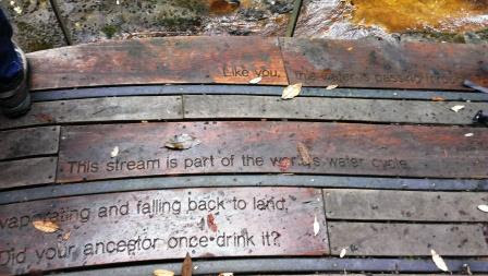
There is a fairly new viewing platform here, with a nice bench to sit on and some thoughtful messages for modern visitors to ponder.

We enjoyed a quick lunch and then got back on the trail before we cooled down too much.  Meandering pleasantly back along the Pipeline Track, we couldn't help but notice Cathedral Rock across the valley, looking very grand (and high and craggy).  All of us (except Lyn, who is very fit) agreed we had in fact been very lucky to not do that walk.  We got back to our cars at 1.30pm.

Back in town we caught up with Kat over a cuppa at Pilgrim Coffee, to hear how the injured James was doing.  Thankfully all seemed to be well.

26 May 2013 - Kermandie Falls

We had a great rollup for this walk, in part because it is not well known and it was a new walk for all of us. We tried out the traditional Kermandie River Road access.  There is another access option described which comes in via Riawunna Rd, which is shorter and easier but apparently is often blocked due to forestry operations.

There were eleven of us:  me, Robert, Bob, Wayne, Austin, Sophie, Caroline, Warren, Julie, Kat and Philip.   Two cars left from our house, and we met the third car at the Kermandie River Road turnoff from the highway below Geeveston.   We proceeded in a convoy from there, because the various route instructions we had dug up were pretty confusing and contradictory.  Indeed we did find that recent forestry roadworks have changed the roadways in this area a lot, but Bob managed to interpret the instructions and get us to our destination, and I've put some clear directions here. 

About 2 km along, there was a signed turnoff (to Hartz Walking Track) up to the left off the farmed river flats, but after that, the signage was non-existent.  After about another 2km of slow going along a rather rough, narrow unsealed winding road, and avoiding two possible turnoffs to the left (to Haulage Rd and to "L"), we reached a small car park. It was lucky we didn't encounter any traffic, because options for passing were scant.

We started walking at about 10.30am. The track heads down the hill here to the left, actually a fire trail which starts with a rock hop through a creek.  After a few hundred metres, there was a left pointing sign to Kermandie Falls and Hartz Mountain Track.  We were lucky to see it as it was heavily obscured by the bushes!  So we headed left up a slope and quickly came upon a well built forestry road which comes off Hermons Rd.  It would be tempting to come in on Hermons Rd, but apparently this also is sometimes locked due to forestry operations.  Also there is no apparent parking spot here.  Looking to the right, there was a solid bridge.

Just before the bridge, heading up to the left, was the track.  The sign had been nicked.  Was someone looking for firewood or something?
Where the sign used to be

Patting ourselves on the back for our successful sleuthing efforts, we set off on the trail. Just on the left Bob found a water tap - this track has all mod cons!

The first half hour of this walk is pleasant, with thick leaf fall underfoot, beautiful mossy trees and rainforest plants.   Do not cross the river, keep going along on the left side of the river. The Kermandie River burbles along prettily on the right, and there are some reasonable spots on the bank for a picnic.


After this the track heads further uphill from the river and deteriorates somewhat.  It has clearly had little attention for years.  There are many treefalls which have been there for some time, and a large treeslide which is fairly recent.

There is a lot of scrambling over large logs, finding footholds on slippery branches,  and several boggy patches.  Without the regular tape flags along the track we would have got quite lost.

Gaiters and sound walking boots are essential, and walking poles highly recommended.  A number of leeches found our warm bodies, and several found their mark.

On the positive side, the rainforest vegetation is lovely and we noticed quite a range of interesting fungi.  There were several tall trees to gape at.  Kat and Robert heard a strange mechanical birdcall, which we later identified as the Superb Lyrebird.  After an hour of steady upstream progress, we reached the junction with the track coming in from Riawunna Rd.


From here it was another 20 minutes to the Falls, which we reached at 12.20pm.


The spectacular Falls are located in a steep rugged valley which apparently is hardly ever in direct sunshine.  A massive pileup of huge logs just down from the Falls is testament to the river's ferocity in flood.


There was a slight drizzle all the time we were at the Falls, which made gathering around our shared picnic lunch quite difficult.  There were only soggy logs and slippery rocks to sit on, and we were envious of Kat and Philip's little foam mats to sit on (great idea!).  There was almost no flat space under the treeferns to spread our goodies, but we managed with the help of Bob's blanket and by passing plates around.  It was quite a feast, as most of us had over-catered.


Half an hour later, as the cold started to seep into us, we packed up and headed back along the track.


We made faster progress on the homeward stretch, getting back in just an hour and a half, at 2.30pm.  After a final leech check, we drove into Geeveston looking for a coffeeshop.   We were surprised to find that the coffeeshop we had in mind was now for sale(!), and the little place across the road was closed.  As plan B we headed to Franklin to the Petty Sessions cafe.   Thankfully this was open, and we found good coffee and tea, and good service. 
 
Total actual walking time:  3.5 hours.
The injury score:  5 leech attacks, one wasp nest attack on Robert, two mud slides by Caroline.
Track quality rating:  Poor.
Signage rating:  Poor.
Value for effort: Low.
The company:  Great.

21 Apr 2013 - Tarn Shelf, Mt Field

Bob had organised ten of us for this walk - me, Robert, Bob, Wayne, Angie, Pauline, Austin, Sophie, Catherine and Peter - and we gathered at our place at 9am on what looked like a perfect autumn day to consider how far we would walk and whether this would affect car sharing decisions.  Looking at the map, we all thought we could make it to Newdegate Hut (5.7km) for lunch and, returning on the same track, get back in a reasonable time.   The full loop circuit including Lake Webster, about 13km, reported at 7 hours for walkers of our vintage, sounded rather too much for all of us.

So we piled into three cars and headed off at about 9.20am, reaching the Lake Dobson carpark at about 10.45am. It's an hour's drive to Mt Field NP, then another 20 mins or so to get up to Lake Dobson.

We were hoping to see the 'fagus "turning", as the traditional day to visit Mt Field to witness this is Anzac Day (April 25), but the 'fagus groves on the road up to Lake Dobson were showing no signs of turning as yet.  There had been reports of snow falling on Mt Field during the week, so we were unsure how much snow would be up there. Personally, I was hoping there would not be too much! Most of us were wearing our thermal long johns for the first time this year, in anticipation of the cold mountain shelf.  After squeezing into our boots, gaiters and fleecy jackets, we set off in great spirits a little before 11am.  Lake Dobson was looking perfect and the track was in great shape.

We took the Urqhart Track up to the left from the Lake Dobson circuit track, and headed up the hill towards the ski fields and Mawson Plateau.  We passed through a pretty pandani (Richea pandanifolia) grove and then struck up a dirt road leading to the ski lodges. 
 
We passed the two lodges and took the fairly level and straight duckboard track westwards across the ski field towards the Lake Seal Lookout.  This section was very easy walking and a great start to the day.
Enjoying the Lake Seal Lookout
The Lake Seal Lookout gave great views over Mt Bridges and towards the area we were about to traverse. Ken Collins says that the landforms here are resistant peaks of Jurassic dolerite, rolling ice-smoothed (glacial) terrain, and rock - shattered by frost during the last ice age in the Pleistocene - now seen as boulderfields. "Some of the intrusive dolerite cooled slowly and formed vertical columns such as Mt Field West. Erosion by frost and ice has created flat bouldery plateaus above the cliffs, glaciers have cut deep into valleys, and the process of solifluction (the mass movement of rock debris in saturated soil) has covered the lower slopes of the range with boulders. These erosive processes have formed tabular landforms".
Tarn Shelf around and to the left, Lake Seal below
The Broad Valley contained a large glacier that eroded a typical U profile.  As well, it deposited moraines along the valley, and eroded a valley step (a cliff or steep slope) between Lake Webster and Lake Seal.  Rock basins carved by a glacier on the Tarn Shelf are now filled by Lake Newdegate and tarns.
Tarn with Pencil Pine
The track from the Lake Seal Lookout to the Rodway Day Shelter was mostly on duckboards, over a slight incline, and we came across occasional tiny patches of snow. The alpine vegetation, the pristine air and the stunning views.....it was a joy to be alive and on the Tarn Shelf.

After the Rodway Shelter, the track was mostly rock-hopping over the dolerite.

We passed a series of beautiful little tarns and saw some lovely groves of 'fagus definitely starting to "turn" into their autumn colours - fantastic!

A little after Johnston Tarn we had a short snack stop, then headed onwards.  The continual rock-hopping was starting to get a bit tiring for most of us.

By the time we reached Backhouse Tarn, it was 1.30pm and we had been walking for 2.5 hours.  Most of us were well and truly ready for lunch and to then head back along the track. We wanted to make sure we were close to Lake Dobson before the evening closed in.  So we enjoyed our packed lunches alongside this lovely tarn.  The weather was still holding up well, with patches of sunshine dancing across the mountainside, and no rain as yet.  A few emerging blisters were addressed!

Bob was determined to achieve our original goal, and decided to press on to Newdegate Hut with Wayne and Peter, with the aim of catching up with us slowpokes on the way back 
The grins say it all!

Lake Newdegate
They caught us much sooner than we expected, rejoining the larger group as we reached the Rodway Shelter.  We were amazed at their energy, as the rest of us were starting to suffer a little by then.

We made speed across the Shelf, along the duckboards.  At the Lake Seal Lookout intersection, we took the left hand track down towards Lake Dobson. This turned out to be mostly rock-hopping, with more good views over Lake Seal and the Broad River valley.   There were some magnificent snow gums, massively twisted by the weather.  This track came out at  the ski lodges and we trundled back down the dirt road, which now seemed very steep.  Another look at the pandani grove, and we were back at charming Lake Dobson at about 4.30pm.

We'd been on the track for five and a half hours, including a half hour lunch stop, and the amount of rock hopping had been a challenge.  Massively pleased with ourselves at our great feat, we fell into our cars and set off home, tired but satisfied.   A possible coffee stop fell through when we found the Possum Shed closed (well, it was after 5pm).  What a shame.

In the car on the way home we made a list of plants seen, and Sophie also made a list -  so between us we have:  Pencil pine (Athrotaxis cupressoides ); Mountain Rocket (Bellendena montana); Cushion plant (Dracophyllum minimum); Fagus (Nothofagus gunnii); Tasmanian Snow Gum (Eucalyptus coccifera); Richea pandanifolia, dracophylla and scoparia; Pencil pine (Athrotaxis cupressoides); Everlasting daisy (Celmisia saxifraga?); Native/mountain pepper (Tasmannia lanceolata);  Snow berry (Gaultheria hispida); Native/mountain redcurrant (Coprosma quadrifida/nitida?); Pineapple grass ( Astelia alpina); Pink mountain berry (Cyathodes parvifolia/juniperina?); Trochocarpa thymifolia; the prostrate conifer Microcachrys tetragona.  And of course there were many more.
Someone mentioned that platypi can often be observed in Platypus Tarn (near Lake Dobson), so that might be a nice short walk for the future.