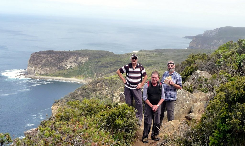
This month Bob led a group on a walk to Shipstern Bluff. The weather wasn't looking too good as they set out, but he could report on FB:
Ignored the weather forecast and walked to Shipstern Bluff today. So
glad I did, the rain held off for most of the walk and I got a day in
the bush with friends, and only a little bit wet!
Celebrating terrific walks with our friends, and collecting tips for next time!
October 2015 - Florentine River via the Timbs Track
After some late withdrawals, due to
(thankfully minor) medical issues, this walk had three participants: Angie
McGowan, George Plumb and Angie’s young neighbour Kailash Walker. Thanks Angie for this excellent story and pictures!
We took with us The Wilderness Society’s
Self Drive Guide notes, downloaded from the TWS website: https://www.wilderness.org.au/upper-florentine-self-drive-guide.
The drive from Hobart to the Timbs Track is about 2 hours. The walk to the
Florentine River is a relaxed 2 hours one-way.
We met up at George’s place in Sandy Bay
and set off at about 9am. The start of the Timbs track is about 21 km past
Maydena, and the small car-park at the side of the road is clearly signposted.
After checking out the new interpretations sign we
started walking at around 11am. The first part of the track, through lovely mixed
forest, was slow-going with lots of fallen trees across the track. But after half
an hour of clambering and diversions we got to more open country, which was much
easier going, although there were a couple of very large puddles which we
skirted around. We discovered at least two species of tadpoles in the puddles!
About
an hour from the track head, there is a wooden platform look-out a short distance
to the right of the track. You can’t see the look-out from the track, but there
is a small painted sign showing the way. From there we had great views of the
surrounding mountains and across the forest to the Florentine.
About another half hour, mostly downhill,
the Timbs Track meets the Old Adamsfield Track. Here we took the left turn
westwards towards the Florentine River. The Adamsfield Track, which is wider
and still has some old cording in places, goes through some lovely forest down
to the River. A few metres before the River, there are two huts. The first, on
the right hand side of the track, is the newly reconstructed Ewes Inn hut –
which would be a very welcome shelter in inclement weather. The second hut, on
the left hand side of the track, is in a ruinous condition.
With a couple of brief stops for snacks and
to check out the wildlife (tadpoles and birds) and the views, we got to the
Florentine River about 1pm, where we had our picnic lunch and refilled water
bottles . We didn’t cross the River, but this would be possible by walking carefully
over some large fallen logs. The old bridge across the river has long gone.
The walk back to the car park took about
1.75 hours, with fewer stops for snacking etc. On the way back along the
Adamsfield Track we saw a tiger snake wriggling away from us. The forecast
showers didn’t eventuate. And we got back to Hobart about 5.30pm.
September 2015 - Mt Misery
Caroline organised this walk to Mt Misery,
a 6km walk past Ranelagh near the Huon Bush retreats - an ascent of
about 280 m on a good track - about 3.5 hours in duration.
The walkers today were George, Lyn, Kat, Philip, James, Wayne, Gerwyn, Bob, Caroline and Warren.
The walk starts at the left of the picnic shelter at Huon Bush Retreats. It leads through wet forest and rainforest, with large stands of personfern, to a sandstone plateau, clothed in heath, that allows views to the southwest wilderness. Crossing the plateau and a saddle you will reach a rocky outcrop with a miserable face! Retrace your steps for much of the way, enjoying the different view you see facing downhill, and finish with a visit to a live tree gutted by fire, and a small waterfall.
Thanks to Kat and Warren for the photos.
The grade is Medium, and the total walk is 6.3km, talking about 3 hours and 30 minutes. Further information can be obtained at www.huonbushretreats.com.
September 2015 - Apsley Gorge
Robert and Di did this walk while enjoying a weekend escape on the East Coast with Wanda.
We thought we'd take a little look at the Apsley River end of the Douglas-Apsley National Park, having not been there before. This is one of Tassie's Parks and Wildlife Service's Great Short Walks, so some details can be found here. PWS suggest doing the walk over the hill and returning along the same path (2-3 hour return, 5.6km return). We used the walk description in "Day Walks Tasmania" by John and Monica Chapman - they suggest doing the full loop i.e. returning along the river bed.
Go 4.5km north of Bicheno, turn left onto Rosedale Road (well signposted), then enjoy 7.5km winding through pleasant farmlands (mostly unsealed), and find the roomy carpark. After signing into the walkers' log there is an option of a short 5 min loop walk to the Lookout over the Apsley River - but NOTE the Lookout is currently closed off for repair.
It is a few minutes' walk down to the Apsley River, which is very pretty, and home to the Australian Grayling (they ask you not to wear sunscreen if you are going for a swim, as it is harmful to the fish). Here you can swim, picnic, and rockhop across to the other side where the Apsley Gorge walk commences (and the longer Leeaberra Walk comes in from the north).
We set off northwestwards from the river at 11am, thinking of just doing a short walk as we hadn't packed a lunch or much in the way of gear. This is a comfortable uphill climb, with lots of nicely made stone steps where required. We spotted a hooded orchid at the side of the path and later on met a chap taking lots of photos of orchids (he'd found a spider orchid).
There are no lookouts along the path, which rises to a long ridge and passes through attractive typical East Coast dry forest. The track was dry and conditions were perfect on this spring day. Lots of spring flowers were out.
When we reached the end of the ridge, we made the snap decision to keep going and do the full loop walk.
There had been plenty of warnings about precautions for people choosing to walk back along the river, such as the Chapmans' "The walk through the gorge requires scrambling over rocks and sturdy footwear is recommended. There is no track through the gorge and it should not be attempted after heavy rainfall". PWS had alarming signs posted showing people falling off rocks and a note that there is no mobile signal in the Gorge. Duly warned, we decided to give it a go. We were wearing sturdy shoes but not boots, which would have made it easier, but it was a beautiful day, so what the heck.
At about midday we reached the river upstream in the Gorge. It is a beautiful spot.
Once again, a great spot for picknicking and swimming, more pristine and a lot more private than at the beginning of the walk.
The Chapmans measured the loop as 6.1km. My recording via Strava showed 8.4km to and from the carpark! I believe Strava.
It took us about 3 hours to rockhop our way down the riverbed back to the walk's start, and it used every muscle in our bodies. There is no marked track, you have to continually judge the best (only?) way forward, having to cross the river again and again to make progress. It was rugged, pristine and beautiful. The rocks ranged from huge boulders to sheer cliff faces to stretches of river gravel, and occasionally some minor bushbashing was required to navigate our way without getting our feet wet (or worse).
Slipping and falling could have been quite serious, and prospects of getting help in a hurry were pretty slim, so our minds were focussed! Di had emergency muesli bars packed (Be Prepared!), so we were able to stop for a snack and let our legs recover a little. It seemed to take forever (we had missed lunch, after all) to rockhop down the many bends, admiring the spouting waterfalls and clear but cold pools.
At about 3pm we made it back to the beginning, exhausted but smug. So the total walk time was 4 hours. Notes for next time: do take lunch and have a good picnic on the beautiful river rocks; be well prepared with rockhopping footwear and contingencies for accidents (such as a Personal Location Beacon PLB); and make sure the river is not high.
We thought we'd take a little look at the Apsley River end of the Douglas-Apsley National Park, having not been there before. This is one of Tassie's Parks and Wildlife Service's Great Short Walks, so some details can be found here. PWS suggest doing the walk over the hill and returning along the same path (2-3 hour return, 5.6km return). We used the walk description in "Day Walks Tasmania" by John and Monica Chapman - they suggest doing the full loop i.e. returning along the river bed.
| With thanks to "Day Walks Tasmania" |
It is a few minutes' walk down to the Apsley River, which is very pretty, and home to the Australian Grayling (they ask you not to wear sunscreen if you are going for a swim, as it is harmful to the fish). Here you can swim, picnic, and rockhop across to the other side where the Apsley Gorge walk commences (and the longer Leeaberra Walk comes in from the north).
We set off northwestwards from the river at 11am, thinking of just doing a short walk as we hadn't packed a lunch or much in the way of gear. This is a comfortable uphill climb, with lots of nicely made stone steps where required. We spotted a hooded orchid at the side of the path and later on met a chap taking lots of photos of orchids (he'd found a spider orchid).
There are no lookouts along the path, which rises to a long ridge and passes through attractive typical East Coast dry forest. The track was dry and conditions were perfect on this spring day. Lots of spring flowers were out.
![]() |
| Comesperma volubile (Blue Love Creeper) |
![]() |
| Banksia marginata |
When we reached the end of the ridge, we made the snap decision to keep going and do the full loop walk.
There had been plenty of warnings about precautions for people choosing to walk back along the river, such as the Chapmans' "The walk through the gorge requires scrambling over rocks and sturdy footwear is recommended. There is no track through the gorge and it should not be attempted after heavy rainfall". PWS had alarming signs posted showing people falling off rocks and a note that there is no mobile signal in the Gorge. Duly warned, we decided to give it a go. We were wearing sturdy shoes but not boots, which would have made it easier, but it was a beautiful day, so what the heck.
At about midday we reached the river upstream in the Gorge. It is a beautiful spot.
Once again, a great spot for picknicking and swimming, more pristine and a lot more private than at the beginning of the walk.
The Chapmans measured the loop as 6.1km. My recording via Strava showed 8.4km to and from the carpark! I believe Strava.
It took us about 3 hours to rockhop our way down the riverbed back to the walk's start, and it used every muscle in our bodies. There is no marked track, you have to continually judge the best (only?) way forward, having to cross the river again and again to make progress. It was rugged, pristine and beautiful. The rocks ranged from huge boulders to sheer cliff faces to stretches of river gravel, and occasionally some minor bushbashing was required to navigate our way without getting our feet wet (or worse).
Slipping and falling could have been quite serious, and prospects of getting help in a hurry were pretty slim, so our minds were focussed! Di had emergency muesli bars packed (Be Prepared!), so we were able to stop for a snack and let our legs recover a little. It seemed to take forever (we had missed lunch, after all) to rockhop down the many bends, admiring the spouting waterfalls and clear but cold pools.
At about 3pm we made it back to the beginning, exhausted but smug. So the total walk time was 4 hours. Notes for next time: do take lunch and have a good picnic on the beautiful river rocks; be well prepared with rockhopping footwear and contingencies for accidents (such as a Personal Location Beacon PLB); and make sure the river is not high.
August 2015 - Chauncy Vale
There were 6 of us:
Kat, Philip, Tony, Lyn, George and Bob.
Chauncy Vale is about a 40 minute drive north of Hobart so we pooled
into two cars and set off on the walk about 10:30am.
There had been some recent rain and the weather prediction
was for light showers so we all prepared for a possible wet walk, but
fortunately the weather held and while it was mostly cloudy, we had some sunny
breaks. The main path to Flat Rock
crosses a creek three times and because of the recent rain we decided to the
detour to The Caves first as we could access that without crossing the creek.
The Caves were fascinating and it was easy to see how they
inspired Nan Chauncy’s books. It was
uphill to The Caves for about 30 minutes, then along a ridge where the caves
were.
| The Caves |
| The Caves |
| The Caves |
| The Caves |
| The Caves |
Then back down to the creek where we caught up with the track to Flat
Rock. The track was well defined and the
detour took about 90 minutes with stops for pictures.
We needed to cross the creek when we rejoined the Flat Rock
track but the creek was low so the crossing was easy. We decided that on the way back we would take
the shorter path to the carpark.
The track to the Flat Rock was wide, mostly dry and at a
constant but easy upward grade. The
bushland was interesting and not what I expected, it seemed to me to be more
like the Victorian Highlands than Tassie bush.
We reached the T junction for walks to the eastern and western lookouts
at about 1:00 which means we had been walking for about 2½ hours. We decided to see the eastern lookout first
which took about another 30 minutes and we had lunch there. The view was over the mountain tops which is
always pleasant, but it wasn’t what I would call magnificent.
| View from Eastern Lookout |
| Lunch at Eastern Lookout |
On the way back down we took the 5 minute walk to the
western lookout which had a unique view of the snow clad Mt Wellington.
| Snow clad Mt Wellington in the distance |
The walk back down took about 2 hours. We probably could have been quicker but the
constant downhill was a strain of my knees and I fear I held the others back.
Walking back alongside the creek to the carpark we saw Eve’s
Bath – a bath shaped rock formation in the creek - which features in one of Nan Chauncy’s books.
| Eve's Bath |
July 2015 - Crescent Beach
Gary organised our July walk, and this was a return to the beautiful Crescent Beach, past Port Arthur. Our last visit here was in July 2010, exactly five years ago!
The walk was deferred by one week due to predicted terrible weather (and it was). The forecast for the second Sunday wasn't much better, with the weather bureau recommending (again) that people stay safe and warm indoors. But we decided to proceed (admittedly fewer of us than usual), and were blessed with reasonable conditions and no-one else on the track!
Bob took these great photos of the day. The weather was clear and the views excellent at the start of the walk.
We had beautiful Crescent Beach to ourselves, how lovely.
The walk was deferred by one week due to predicted terrible weather (and it was). The forecast for the second Sunday wasn't much better, with the weather bureau recommending (again) that people stay safe and warm indoors. But we decided to proceed (admittedly fewer of us than usual), and were blessed with reasonable conditions and no-one else on the track!
Bob took these great photos of the day. The weather was clear and the views excellent at the start of the walk.
![]() |
| The walk starts at the Remarkable Cave carpark. |
![]() |
| Crescent Beach beckons |
![]() |
| Crescent Beach |
![]() |
| Crescent Beach |
![]() |
| Conditions on the return leg were not so bright |
Subscribe to:
Posts (Atom)


