On a day that threatened "rain falling as snow", we were really lucky to enjoy a sunny (but still cold) winter's day for this walk. The Bicentennial Walk is a treat, taking advantage of the (thankfully) preserved skyline reserves above Sandy Bay. There were 9 of us - Di, Robert, Bob, Kat, Philip, Alison, Julia, and two visitors from Coonabarabaran, Noella and Kate. We did the car shuffle, leaving two cars at the ample carpark near Bus Stop 32 on the Channel Highway in Taroona, and driving to meet the others at the top of Lambert Ave, Sandy Bay.
We set off from the top of Lambert Ave at about 11.15am. The track leads first through the top end of Lambert Park, does a small dogleg to the right at Churchill Ave, then heads steadily up the hill towards the Mt Nelson Signal Station. It is a long and steady
climb through relatively dry open bushland, well documented in the Hobart City Council's Bicentennial Park pamphlet. The track is well graded and maintained, and we caught a terrific view back towards Mt Wellington which had a good covering of snow.
There are several other access points to the walk from the top of Sandy Bay streets. For an easier walk to the Signal Station, you can park at the top of Enterprise Street - the track from here on is fairly level and offers easy strolling. From the level top track along the ridge we enjoyed great views back towards the city over the Derwent.
By about 12.15 we were at the Signal Station Cafe, which was quite busy. No problem, we had a booking. As it was lunchtime, we tried out the menu - mushrooms with polenta, ricotta hotcakes, steak sandwiches, sweet potato and pear soup were yummy. And the coffee was good.
After a short stop to drink in the fantastic views over the lower Derwent,
the group divided, with Alison and Julia choosing to return to Sandy Bay on the Bicentennial track.
The rest of us took at look at the Truganini memorial and then headed down the track through Truganini
Reserve. This Reserve has a wetter microclimate than the Bicentennial track, being moister and thicker. Unfortunately the track was badly (i.e. not!) drained, the timber step edges and exposed roots on the path were slippery and the steps were irregular and often too high. Actually the track was a bit dangerous in terms of potential slips and (actual) damage to knees and hips - I feel a complaint to Council coming on! The bush was pretty though, and the segments running alongside Cartwright Creek are pleasant. This is a shorter and steeper descent from the ridge than the Bicentennial route, taking only about half an hour.
Celebrating terrific walks with our friends, and collecting tips for next time!
Late May 2012 - Cape Hauy
We (Lyn, Sophie, Philip, Kat, Robert and Di) were some of the first walkers to check out the new trackwork on the Cape Hauy track, which has
recently been renovated as part of the developing Three Capes walk. We found it to be first class, apart from some recent little washouts due to recent heavy rains, and some of the trackwork gear was still sitting on the track waiting to be helicoptered out. There is a LOT of new stonework, including a dear little stone bridge, and kilometres of expertly made steps. In fact, there were 2019 stone steps, as counted by Philip! The weather held out for us, with some small showers just missing us. The views around Fortescue Bay and up and down the coast were fantastic.
Pristine and stunningly beautiful, what more can we say?
The walk:
This is now an 8 km walk, and still takes 4 hour return. NPWS rate it as Grade 4: "Bushwalking experience recommended. Tracks may be long, rough and very steep. Directional signage may be limited". We can attest that it still warrants that Grade - on account of its steepness! There are lots of ups and downs. Hearts and knees are tested. We met at Fortescue Bay, in the carpark near the boat ramp at 10.30, set out just before 11am and were back just before 3pm.
Just
out of Fortescue Bay we met a pademelon, lolling back, quite at ease,
next to the path. Soon after we came across a couple of Forester
Kangaroos. Fantastic! The walk rises through a variety of heath and
woodland, where Kat spotted some robins, and levels off for a while,
before coming to
the magnificent views over the Cape. From there the track dives down
(and up again!) across the headland. Here we spotted some New Holland
Honeyeaters and a pair of Black Cockatoos.
We had a picnic lunch at the Cape, overlooking the mighty dolerite Candlestick, the Mitre Rock and looking out to the Hippolyte rocks.
The spectacular dolerite columns and cliffs at Cape Hauy are popular areas for climbing and abseiling.
We limited ourselves to gawking at the cliffs and the blue crashing seas far below.
The walk back was pretty long and steep, climbing back up to the headland and then descending steadily back down to Fortescue Bay.
We tried to give some business to the Blue Seal cafe at Eaglehawk Neck on the way home, but apparently their "Open" sign doesn't mean much(!). The Dunalley Waterfront Cafe was an excellent choice for view, service, and quality coffee, tea and Two Metre Tall ale.
However, there were after effects... I think we all suffered for the next few days from sore calves from all the steps!
Getting there:
Take Arthur Highway (A9) to the junction with Fortescue Bay road (C344), which is 4km south of Taranna and 4km north of Port Arthur. Turn into C344 and drive 12km to Fortescue Bay. This road is an unsealed forestry road and not in great condition, but is OK for 2WD vehicles and mountain bikes. It is a 90 minute drive from the city to the carpark. Note: National Park car stickers/membership is required.
Pristine and stunningly beautiful, what more can we say?
The walk:
This is now an 8 km walk, and still takes 4 hour return. NPWS rate it as Grade 4: "Bushwalking experience recommended. Tracks may be long, rough and very steep. Directional signage may be limited". We can attest that it still warrants that Grade - on account of its steepness! There are lots of ups and downs. Hearts and knees are tested. We met at Fortescue Bay, in the carpark near the boat ramp at 10.30, set out just before 11am and were back just before 3pm.
We had a picnic lunch at the Cape, overlooking the mighty dolerite Candlestick, the Mitre Rock and looking out to the Hippolyte rocks.
The spectacular dolerite columns and cliffs at Cape Hauy are popular areas for climbing and abseiling.
We limited ourselves to gawking at the cliffs and the blue crashing seas far below.
The walk back was pretty long and steep, climbing back up to the headland and then descending steadily back down to Fortescue Bay.
We tried to give some business to the Blue Seal cafe at Eaglehawk Neck on the way home, but apparently their "Open" sign doesn't mean much(!). The Dunalley Waterfront Cafe was an excellent choice for view, service, and quality coffee, tea and Two Metre Tall ale.
However, there were after effects... I think we all suffered for the next few days from sore calves from all the steps!
Getting there:
Take Arthur Highway (A9) to the junction with Fortescue Bay road (C344), which is 4km south of Taranna and 4km north of Port Arthur. Turn into C344 and drive 12km to Fortescue Bay. This road is an unsealed forestry road and not in great condition, but is OK for 2WD vehicles and mountain bikes. It is a 90 minute drive from the city to the carpark. Note: National Park car stickers/membership is required.
Early May 2012 - Russell Falls and Lady Barron Falls
A small group of explorers this time, Angie, Lyn, Robert and Di. We were keen to see a new part of Mt Field NP and to catch a sight of the autumn colours of the "fagus" (Nothofagus gunnii).
Luckily Robert thought to check that we had our current NP pass on the windscreen (we didn't!). After fixing that, we made a quick visit to the Hobart Farmers' Market to stock up on cheese and seedlings, and then headed west towards Mt Field. It was an hour and a half drive (make sure you've got some pleasant music on board for the drive home!).
We parked near National Park visitors' centre,and took the track to Russell Falls. This is a short 10 minutes walk on a sealed path. The falls are three tiered and stunningly beautiful.
We took the path up to the right, which offers a closer view of Russell Falls from halfway up, and then another view over the valley from the top of the falls (a creek with an infinity edge!).
Very impressive.
We took a short diversion to look at the unassuming but unusually curved Horseshoe Falls
and then continued, following the signed track southwest through the forest.
There were heaps of fascinating mushrooms and other fungi to marvel at all along the way.
Watch out for the slippery edges of the boardwalks - we had a couple of tumbles. We took the left hand circuit around the Tall Trees walk. We estimated the height of one of the tall E. regnans at 72.1 m using the clinometer, and failed to agree with the answer provided by NPWS. Clearly the tree had been recently pruned by the winds!
Crossing over Lake Dobson Rd, we proceeded through more wet forest. The Lady Barron Falls were lovely. On the track back towards the visitors centre there is a new detour over the hill, involving many timber steps(!), but we had a timely rest for a snack at the top. This track emerges into distinctly drier forest on the hilltop and then descends pleasantly towards civilisation.
This walk took us 3 hours, including many stops to admire mushrooms, tall trees, and to take photos. It could easily be done in 2 to 2.5 hours.
We drove up to Lake Dobson, stopping en route for some spectacular shows of the Fagus (near the takeoff points to Mt Field East).
Lyn had her first look at Lake Dobson, and we were pleased to see a neat new boardwalk at the lake's edge.
Driving back home, we came across a new coffeeshop in New Norfolk, the Patchwork Cafe near the Willow Court Motel. Good coffee, yummy snacks and attractive patchwork quilts to admire.
Luckily Robert thought to check that we had our current NP pass on the windscreen (we didn't!). After fixing that, we made a quick visit to the Hobart Farmers' Market to stock up on cheese and seedlings, and then headed west towards Mt Field. It was an hour and a half drive (make sure you've got some pleasant music on board for the drive home!).
We parked near National Park visitors' centre,and took the track to Russell Falls. This is a short 10 minutes walk on a sealed path. The falls are three tiered and stunningly beautiful.
We took the path up to the right, which offers a closer view of Russell Falls from halfway up, and then another view over the valley from the top of the falls (a creek with an infinity edge!).
Very impressive.
We took a short diversion to look at the unassuming but unusually curved Horseshoe Falls
and then continued, following the signed track southwest through the forest.
There were heaps of fascinating mushrooms and other fungi to marvel at all along the way.
Watch out for the slippery edges of the boardwalks - we had a couple of tumbles. We took the left hand circuit around the Tall Trees walk. We estimated the height of one of the tall E. regnans at 72.1 m using the clinometer, and failed to agree with the answer provided by NPWS. Clearly the tree had been recently pruned by the winds!
Crossing over Lake Dobson Rd, we proceeded through more wet forest. The Lady Barron Falls were lovely. On the track back towards the visitors centre there is a new detour over the hill, involving many timber steps(!), but we had a timely rest for a snack at the top. This track emerges into distinctly drier forest on the hilltop and then descends pleasantly towards civilisation.
This walk took us 3 hours, including many stops to admire mushrooms, tall trees, and to take photos. It could easily be done in 2 to 2.5 hours.
We drove up to Lake Dobson, stopping en route for some spectacular shows of the Fagus (near the takeoff points to Mt Field East).
Lyn had her first look at Lake Dobson, and we were pleased to see a neat new boardwalk at the lake's edge.
Driving back home, we came across a new coffeeshop in New Norfolk, the Patchwork Cafe near the Willow Court Motel. Good coffee, yummy snacks and attractive patchwork quilts to admire.
March 2012 - Deep Hole beach, Ida Bay
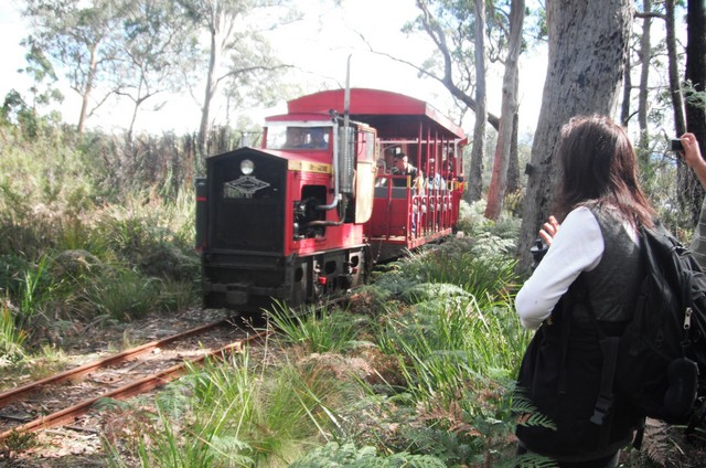
Eight of us made up the party, arriving in our pooled cars at the Ida Bay railway station at about 10.30am on a perfect autumn day. After securing our tickets for the return leg ($14 for an adult) on the historic Ida Bay Railway, we set off to follow firstly a four wheel drive track and then the rail lines to Deep Hole Beach. Donnelly's Gates were curious - a well maintained front gate and garden, now in the middle of nowhere.
The walk to Deep Hole bay is 7km long, and took us 1.5 hours. We stopped briefly at the Cemetery at Ida Bay, where young members of the Tyler family (some early miners?) and the Jager family (early fisherfolk - later at the Dover Hotel Robert saw a picture of a boat they had built) are buried.
The train takes about 45 mins to get to Deep Hole, you have to keep an ear out for it and get out of the way!
Walking to the end of the lines out to the old jetty, Philip found a more secluded part of Deep Hole beach, where we had our lunches. No-one was game for a swim, although the water looked lovely (there is a good safe shelf for kiddies).
Some of us enjoyed a solitary stroll along the beautiful beach.
We caught the return leg of the 1.30 Ida Bay train, which left Deep Hole at about 2.40pm. What a luxury!
Back at Ida Bay railway station, we piled into our cars and headed back to Dover pub for a beer.
Directions:
Leave Hobart at 9am. Follow the
Huon Highway (A6), turning off before Southport toward Hastings (C635)
. Head towards Lune River, then Ida Bay, park at the Railway station. Buy train tickets from the cafe. Walk from here on the four wheel drive track (near the railway crossing) towards Deep Hole
Bay/Southport Bluff.
Option for next time:
This would require taking the 9.30am train to Deep Hole Bay, arriving there about 10.15am. Walk about 4 hours. Catch the return leg of the 3.30pm train at 4.40pm.
On the list for 2012
September - Growling Swallet, Maydena
October - Collins Bonnet, Mt Wellington OR Cathedral Rock via Kat's house
November - Shadow, Forgotten Lakes, Lake St Clair - 4hrs walk, views, need good weather December - Cape Raoul, Tas Peninsula - great views, seals, possible S2H yacht sightings
October - Collins Bonnet, Mt Wellington OR Cathedral Rock via Kat's house
November - Shadow, Forgotten Lakes, Lake St Clair - 4hrs walk, views, need good weather December - Cape Raoul, Tas Peninsula - great views, seals, possible S2H yacht sightings
More good ideas:
Maria Island
Mt Wedge
Labillardiere Peninsula - time this for spring flowers?
Schnells Ridge
Shipstern Bluff, Tasman Peninsula - 4hr return
Lake Skinner - rec by Caroline
North, overnighter - suggested by Lyn
February 2012 - Pelverata Falls
This
walk slipped into early March because of unseasonally high temperatures
on the weekend we had originally scheduled this walk.
Pelverata Falls: A very
tall waterfall in the Snug Tiers (approximately 114 metre drop), a 2-3
hour return walk on a good track to a viewing platform.
The
walk took us an hour each way, although Robert complained that we didn't
make enough stops to admire the views.
Directions:
Take the Southern Outlet to the Sandfly
turnoff. Turn left, and then turn right almost immediately onto Pelverata
Road. (This might be a good spot to meet up).
Drive
to Pelverata, which is a further
11km. Just past the township, turn left onto Crosswells Rd (well
signposted), go 1km
up the hill to a clearly marked parking area. You can also approach
from the south, from below Huonville, although this road is mostly
gravel.
The walk :
Follow the sign along a pretty leaf littered trail for
approx 0.5km to where it joins up with a vehicle-wide track, Vincents Track.
This
follows a farm perimeter east before turning sharply right (sign
posted "Falls"), and heading south-east through thicker bush.
The track has a steady but gentle climb. The last 15 minutes are
steeper and rockier, making me wish I had worn proper walking
boots/shoes. The
walk curves slightly left into sight
of the falls. There is a new very solid viewing platform (no seats or
tables) to stop and enjoy the falls and the little valley where
Pelverata and Slippery Creeks meet.
Scrambling down to the creek seems to be discouraged these days.
The walk back is a nice gentle downwards amble.
January 2012 - old Kaoota railtrack
This
is an easy walk along the line of the old railway track of the now
defunct coalmines of Kaoota, just south of Sandfly. Caroline, Bob, Di,
Robert and Lyn were the intrepid walkers on this very hot day. We did a
car shuffle, leaving one car at the Kaoota end and returning to start
the walk at the Nierinna end. We were lucky to miss being caught up in
the Targa Tasmania route, which had used the Pelverata Road that morning
and had finished just before we arrived.
The walking track was level, all under light bush cover, and took about an hour and a half.
Subscribe to:
Posts (Atom)