26 Sept 2012 - Summit Loop, Knocklofty

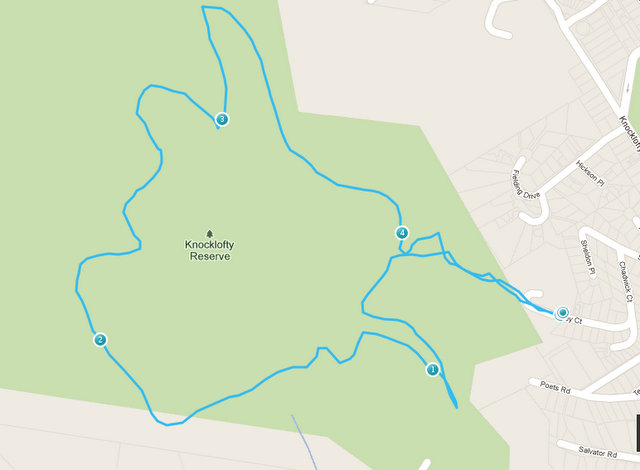
Today was a glorious Spring morning, and the bush fringes of the mountain park were irrestible.  This is my favourite local walk, a one hour circuit of Knocklofty via the Summit Loop track.  It is 4.5 km long.


I usually access this walk from the top of Kirby Court. Unfortunately the usual parking area up next to the old Pacific Vista hotel is closed off at present (for revegetation, I think) so if arriving by car you need to park at the turn around area at the end of Kirby Court.  Walk up what looks like the driveway of the old hotel, walk through the closed off car park, veer left up the bush track.

I like to do this loop clockwise, starting by turning hard left where the bush track emerges into a grassland area, and strolling through the meadow on the left of the frogponds.  Turn left at the level track, heading southwards and towards the Knocklofty lookout.  Today the wattles were a riot of spring blossom. 


Just past here is the historic spot where Glover stood to paint his famous view down the Derwent.

The track here is level and very well maintained, both by the Council and by the loyal and hard working volunteers of the group Friends of Knocklofty.  The track can be accessed near here from the top of Poets Rd.

The view from Knocklofty Lookout is panoramic and just stunning on a clear day.  The track can be accessed near here from the top of Forest Road.


From here, backtrack slightly and take the track to the left and up the hill.  The next 20 minutes are fairly steep and steady, with views towards the mountain as you come around the back of Knocklofty.  Finally you reach the top of hill, the halfway mark of the loop.  This is where the track from Mt Stuart meets the Summit Loop. Turn right.

It's great to be at the top!  Here the dry schlerophyll bush thins out a little and the sunshine washes through.  You can often see wallabies bouncing around up here.

The reward for the 20 minutes uphill slog is the relaxing downhill meander through pretty bush.  Halfway down, on the right hand side, is an attractive wood bench seat - a great spot for a picnic.


While enjoying a drink or a snack, you can enjoy a great view over West Hobart towards the bridge.

The track continues downhill and then around a level closure of the Loop track.  I like to stop and listen for frogs at the Frog Dam just before exitting the park.

UPDATE January 2015:
The downhill section has been rebuilt to remove steps.

Here's another route to access the Summit Loop, from the carpark at the top of Poets Rd:

1 Sept 2012 - Three Thumbs, Orford

The first day of Spring!  It was a lovely day, sun shining and all seeming right with the world.  Six of us set out (Di, Robert, Catherine, Peter, Kat and Philip).   We approached the Three Thumbs walk from the Spring Bay end, because we knew  that the shorter approach (via Copping) was unavailable.  Robertson's Bridge (over Sandspit River) has been washed out (again) and the last we had heard on the news was that no-one was volunteering to rebuild it.  We left town at 10am, and it took an hour and 20 mins to get to the start of the walk. 

Driving directions: 
Tasman Highway (A3) from Sorell to Orford. Turn right just at the bridge onto Charles St (C320) (toward Wielangta Rd). Before 1 km along, where the road is signed as becoming Rheban Rd, turn right onto Wielangta Rd. This turnoff is badly signposted! There is also  a disconcerting "detour" sign not a long away along the road. After 4 km, turn right onto a forestry road - there is a good sign here to the Three Thumbs picnic area. Drive uphill to the start of the Three Thumbs track (well marked). This is at a big bend in the road (the road leads further on to the Thumbs picnic area).  Park here. At the picnic area there is a shelter (and that's about all), but good views to be had over the coast to Maria Island. 

The walk: 
Suits: Competent (fit, some steep sections, footing variable, some wayfinding required)    
Time: 2 hours return            Length: 4km 
After an initial steep start, the track climbs gently to the ridge line of  the Three Thumbs. Then there is a signposted option to take the Forest Walk to the left. We took the right fork, which follows the ridge line along over a few bumps (the Thumbs) to the highest point at 549 metres. 

 The track was generally well formed and marked with cairns and marking tape, going through dry eucalyptus forest.  There is no water available along the ridge.   At the Three Thumbs peak there is a trig station and some nice flat rocks to sun yourself on.  

Unfortunately the trees around the summit have grown and tend to obscure the view (dammit). 

Robert got the prize for the best gourmet picnic today.


On the way back, we took the Forest Walk option to the right, making a loop of the walk. This passed to the west side of Thumb number 2, dipping down into a moister temperate rainforest microclimate - lots of pepperberry, blechnum ferns and damp logs.  We heard lots of birds but were not good at identifying them!  The track was fairly overgrown, with some fallen trees providing obstacles to slide around. No leeches though :)   Despite the steep descent into the valley the ascent back to the main Thumbs track was surprisingly easy.  And the Forest Walk route took the same amount of time as the ridgeline walk.

 We had planned to visit the Scorchers by the River Pizza Cafe in Orford for drinks and snacks after the walk. Unfortunately it was closed for the August quiet season and we had to make do with the with cafe on the corner, where the sporting themed decor was decidedly odd.

Early August 2012 - Tatnells Hill

Wondering about the forecast for a cold front coming over in the middle of the day, we headed off in gorgeous sunshine to the Tasman Peninsula.  There were 7 of us for our walk to Tatnells Hill i.e. me, Robert, Kat, Philip, Bob, Catherine and Peter.  It took just an hour and a quarter to get to the Waterfall Bay carpark from the city. 

After our first look at the beautiful bay, we kitted up for the walk. We had been warned there were leeches on this walk, so most of us had gaiters on today.  Everyone was impressed by Robert ‘s and my gaiters (now possibly collectors' items) which were designed to snugly wrap under and around our boots.  Nothing was going to get through there!  

We headed off at 10.30am, via the track starting on the northern side of the carpark.  We followed the clifftops for about 15 minutes to Falls Camp, where the waterfall careens down the rocks.   

We took the side trip to Waterfall Bluff, which was a lovely leaf littered, level walk through pretty bushland along the clifftops.  There were fantastic views out over the sea and to the north along the way. 
   We saw no whales, unfortunately.


 At the Bluff, there were excellent views south to Cape Hauy, scene of one of our recent walks. 

The Waterfall Bluff diversion took about 30 minutes. 

Back near the Falls Camp, the sign pointed the way upwards towards Fortescue Bay and Tatnells Hill. The track climbed steadily and fairly steeply up the valley, criss crossing the creek, through wet rainforest, with its resident leeches taking some interest as we passed.  Near the top of the ridge we passed the side track to Clemes Hill on the left – this was well signposted.  Soon after this we reached the more open ridge walk, and the open tops of Tatnells Hill at about 12.30pm.  

At the top there were some large flat rocks, perfect for sitting in the sun, enjoying the view and eating our lunches.  The views were out to sea and to the north.  It was too high to imagine one could see whales from there!

We returned the way we had come, with Kat battling to make my walking pole work properly.  We decided in the end that it was cheap and nasty, and I was glad that Robert had found a sturdy wooden stick for me instead.  The walk back seemed much faster somehow, certainly more enjoyable than the upward track, and we were back at the carpark at 2.30pm, just when the skies opened up.  What good timing!

Once again we were confounded by strange signage of cafesThe Dunalley Waterfront CafĂ© had its collapsible sign out on the highway, but we actually found it closed. WTF? Plan B was the Dunalley Hotel, inspiring by its quality of service and food (not).  The beer was fine, though.

Post walk reports:
Robert found evidence of a leech attack on his shin! 
I had no pain in my knees the next day - proving to myself that using a (good quality) walking pole/stick to take some of the weight is very useful. 

Driving Directions:
Drive to Tasman Peninsula, just after Eaglehawk Neck turn left onto Blowhole Rd.  After 2 km, turn right onto Waterfall Bay Road, just before the Penzance Motel.  Park at Waterfall Bay carpark (80km from Hobart, an hour and a quarter drive).

June 2012 - Bicentennial Walk and Truganini Reserve

On a day that threatened "rain falling as snow", we were really lucky to enjoy a sunny (but still cold) winter's day for this walk.   The Bicentennial Walk is a treat, taking advantage of the (thankfully) preserved skyline reserves above Sandy Bay.  There were 9 of us - Di, Robert, Bob, Kat, Philip, Alison, Julia, and two visitors from Coonabarabaran, Noella and Kate.  We did the car shuffle, leaving two cars at the ample carpark near Bus Stop 32 on the Channel Highway in Taroona, and driving to meet the others at the top of Lambert Ave, Sandy Bay.  

We set off from the top of Lambert Ave at about 11.15am. The track leads first through the top end of Lambert Park, does a small dogleg to the right at Churchill Ave, then heads steadily up the hill towards the Mt Nelson Signal Station.  It is a long and steady climb through relatively dry open bushland, well documented in the Hobart City Council's Bicentennial Park pamphlet.  The track is well graded and maintained, and we caught a terrific view back towards Mt Wellington which had a good covering of snow.

There are several other access points to the walk from the top of Sandy Bay streets.  For an easier walk to the Signal Station, you can park at the top of Enterprise Street - the track from here on is fairly level and offers easy strolling.  From the level top track along the ridge we enjoyed great views back towards the city over the Derwent.

By about 12.15 we were at the Signal Station Cafe, which was quite busy.   No problem, we had a booking.  As it was lunchtime, we tried out the menu - mushrooms with polenta, ricotta hotcakes, steak sandwiches, sweet potato and pear soup were yummy. And the coffee was good.


After a short stop to drink in the fantastic views over the lower Derwent,


 the group divided, with Alison and Julia choosing to return to Sandy Bay on the Bicentennial track.

The rest of us took at look at the Truganini memorial and then headed down the track through  Truganini Reserve.  This Reserve has a wetter microclimate than the Bicentennial track, being moister and thicker.    Unfortunately the track was badly (i.e. not!) drained, the timber step edges and exposed roots on the path were slippery and the steps were irregular and often too high.  Actually the track was a bit dangerous in terms of potential slips and (actual) damage to knees and hips - I feel a complaint to Council coming on! The bush was pretty though, and the segments running alongside Cartwright Creek are pleasant. This is a shorter and steeper descent from the ridge than the Bicentennial route, taking only about half an hour.


Late May 2012 - Cape Hauy

We (Lyn, Sophie, Philip, Kat, Robert and Di) were some of the first walkers to check out the new trackwork on the Cape Hauy track, which has recently been renovated as part of the developing Three Capes walk.  We found it to be first class, apart from some recent little washouts due to recent heavy rains, and some of the trackwork gear was still sitting on the track waiting to be helicoptered out.  There is a LOT of new stonework, including a dear little stone bridge, and kilometres of expertly made steps. In fact, there were 2019 stone steps, as counted by Philip!  The weather held out for us, with some small showers just missing us.  The views around Fortescue Bay and up and down the coast were fantastic.

Pristine and stunningly beautiful, what more can we say? 

The walk:
This is now an 8 km walk, and still takes 4 hour return.  NPWS rate it as Grade 4:  "Bushwalking experience recommended.  Tracks may be long, rough and very steep.  Directional signage may be limited".  We can attest that it still warrants that Grade - on account of its steepness!   There are lots of ups and downs. Hearts and knees are tested.  We met at Fortescue Bay, in the carpark near the boat ramp at 10.30, set out just before 11am and were back just before 3pm.

Just out of Fortescue Bay we met a pademelon, lolling back, quite at ease, next to the path.  Soon after we came across a couple of Forester Kangaroos.  Fantastic!  The walk rises through a variety of heath and woodland, where Kat spotted some robins,  and levels off for a while, before coming to the magnificent views over the Cape.  From there the track dives down (and up again!) across the headland.   Here we spotted some New Holland Honeyeaters and a pair of Black Cockatoos.


We had a picnic lunch at the Cape, overlooking the mighty dolerite Candlestick, the Mitre Rock and looking out to the Hippolyte rocks.


The spectacular dolerite columns and cliffs at Cape Hauy are popular areas for climbing and abseiling.

 We limited ourselves to gawking at the cliffs and the blue crashing seas far below.

The walk back was pretty long and steep, climbing back up to the headland and then descending steadily back down to Fortescue Bay.

We tried to give some business to the Blue Seal cafe at Eaglehawk Neck on the way home, but apparently their "Open" sign doesn't mean much(!).  The Dunalley Waterfront Cafe was an excellent choice for view, service, and quality coffee, tea and Two Metre Tall ale.

However, there were after effects...  I think we all suffered for the next few days from sore calves from all the steps!

Getting there:
Take Arthur Highway (A9) to the junction with Fortescue Bay road (C344), which is 4km south of Taranna and 4km north of Port Arthur. Turn into C344 and drive 12km to Fortescue Bay. This road is an unsealed forestry road and not in great condition, but is OK for 2WD vehicles and mountain bikes. It is a 90 minute drive from the city to the carpark.  Note: National Park car stickers/membership is required. 

Early May 2012 - Russell Falls and Lady Barron Falls

A small group of explorers this time, Angie, Lyn, Robert and Di.  We were keen to see a new part of Mt Field NP and to catch a sight of the autumn colours of the "fagus" (Nothofagus gunnii).

Luckily Robert thought to check that we had our current NP pass on the windscreen (we didn't!).  After fixing that, we made a quick visit to the Hobart Farmers' Market to stock up on cheese and seedlings, and then headed west towards Mt Field. It was an hour and a half drive (make sure you've got some pleasant music on board for the drive home!).

We parked near National Park visitors' centre,and took the track to Russell Falls. This is a short 10 minutes walk on a sealed path. The falls are three tiered and stunningly beautiful.


We took the path up to the right, which offers a closer view of Russell Falls from halfway up, and then another view over the valley from the top of the falls (a creek with an infinity edge!).

Very impressive.
We took a short diversion to look at the unassuming but unusually curved Horseshoe Falls

and then continued, following the signed track southwest through the forest.
There were heaps of fascinating mushrooms and other fungi to marvel at all along the way.

Watch out for the slippery edges of the boardwalks - we had a couple of tumbles.  We took the left hand circuit around the Tall Trees walk. We estimated the height of one of the tall E. regnans at 72.1 m using the clinometer, and failed to agree with the answer provided by NPWS.  Clearly the tree had been recently pruned by the winds!

Crossing over Lake Dobson Rd, we proceeded through more wet forest.  The Lady Barron Falls were lovely.   On the track back towards the visitors centre there is a new detour over the hill, involving many timber steps(!), but we had a timely rest for a snack at the top.  This track emerges into distinctly drier forest on the hilltop and then descends pleasantly towards civilisation.
This walk took us 3 hours, including many stops to admire mushrooms, tall trees, and to take photos. It could easily be done in 2 to 2.5 hours.

We drove up to Lake Dobson, stopping en route for some spectacular shows of the Fagus (near the takeoff points to Mt Field East).

Lyn had her first look at Lake Dobson, and we were pleased to see a neat new boardwalk at the lake's edge.
Driving back home, we came across a new coffeeshop in New Norfolk, the Patchwork Cafe near the Willow Court Motel.  Good coffee, yummy snacks and attractive patchwork quilts to admire.

March 2012 - Deep Hole beach, Ida Bay

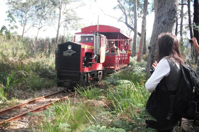
Eight of us made up the party, arriving in our pooled cars at the Ida Bay railway station at about 10.30am on a perfect autumn day.   After securing our tickets for the return leg ($14 for an adult) on the historic Ida Bay Railway, we set off to follow firstly a four wheel drive track and then the rail lines to Deep Hole Beach.  Donnelly's Gates were curious - a well maintained front gate and garden, now  in the middle of nowhere.  

There was supposed to be a walking track from here which meandered around the track but that does not seem to exist any more.  So we walked along the tracks themselves.  This wasn't too hard, but meant more concentration on each step.  As we discovered afterwards, walking along the tracks also means picking up a fair bit of engine oil on the bottom of your trousers!  Luckily the oil came out OK following a good soak.  

The walk to Deep Hole bay is 7km long, and took us 1.5 hours.  We stopped briefly at the Cemetery at Ida Bay, where young members of the Tyler family (some early miners?) and the Jager family (early fisherfolk - later at the Dover Hotel Robert saw a picture of a boat they had built) are buried.  

The train takes about 45 mins to get to Deep Hole, you have to keep an ear out for it and get out of the way! 
  

 Walking to the end of the lines out to the old jetty, Philip found a more secluded part of Deep Hole beach, where we had our lunches.  No-one was game for a swim, although the water looked lovely (there is a good safe shelf for kiddies). 

Some of us enjoyed a solitary stroll along the beautiful beach.
 
We caught the return leg of the 1.30 Ida Bay train, which left Deep Hole at about 2.40pm. What a luxury!

The views were better with a little elevation, and not having to watch our feet!

Back at Ida Bay railway station, we piled into our cars and headed back to Dover pub for a beer.  

Directions:
Leave Hobart at 9am.   Follow the Huon Highway (A6), turning off before Southport toward Hastings (C635) .  Head towards Lune River, then Ida Bay, park at the Railway station.  Buy train tickets from the cafe.  Walk from here on the four wheel drive track (near the railway crossing)  towards Deep Hole Bay/Southport Bluff. 

Option for next time:
Southport Lagoon and Southport Bluff: Take the railway to Deep Hole beach, then walk.  Easy grade, 2 hours return to Southport Lagoon and 2 to 3 hours return to Southport Bluff from Deep Hole. Round trip via Lagoon AND Bluff is 3 to 4 hours return. A profusion of flowering native plants may be seen in November and December.  

This would require taking the 9.30am train to Deep Hole Bay, arriving there about 10.15am.  Walk about 4 hours.  Catch the return leg of the 3.30pm train at 4.40pm.