This was a return visit for some of us - we did this walk in March 2010, on a hot sunny day - and a first for others. Given the timing of this walk, just after Anzac Day, we were expecting to be able to see the 'fagus in its autumn colours on Lake Dobson Road. Our thoughts were also with our friends who were expressing their support for the rainforest just around the back of Mt Field in the Florentine.
Di, Robert, Caroline, Bob and Lyn met at Wayne's place at 8am to pile into two cars for the trip. It was a cold morning, the first real cold snap of winter had swept over southern Tasmania the previous day, but the outlook was for a fine day. It wasn't until we got to the Mt Field Visitors' Centre an hour later that we realised the weather would be grimmer than it had appeared in town. There was a hint of rain and it was definitely cooler already.
As we climbed Lake Dobson Road, the outdoor temperature steadily dropped, till it reached 6 degrees. We saw our first snow of the season, it was enchanting. But surprisingly, the 'fagus on the bend in the road had not started to turn! We did a clever car shuffle, leaving one car in the lower carpark, so that we could avoid a dreary 2km at the end of the walk, climbing up the road to the top carpark. In the top carpark, which was covered in pristine snow when we arrived, we pulled on as many layers as we had. Those without thermals, gaiters and raincoats were wishing they'd had more time to prepare.
At about 10.15am we set off into the pretty first section of the path, through pure snow, enjoying the thought that only native wildlife (wallaby?) had been on the path before us today.
We crossed Lake Dobson Rd and walked into the (closed) Lake Fenton carpark. There was a track entering the carpark on the right which had us confused. But we continued straight ahead under the base of the dam and were soon rewarded with a proper sign pointing to our track.
The snow was a couple of inches thick and the snowmelt was running down the track, meaning a lot of hopping from rock to solid ground to root, and the occasional splosh when we missed.
In the areas of rocky scree, the snow covered not only the rocks but also the gaps around them, so the walker at the front had to work harder to spot where the track was and was pretty tentative with placing the first footprints of the day (except for the wombats!).
So our rate of progress was fairly slow.
But we were surrounded by beauty.
When we got to the turnoff to Seager's Lookout we thought we would give that a miss today, given the conditions. We continued on, with the track mostly uphill. It was an impressive view back over Lake Fenton and towards the Tarn Shelf, with lots of chilly clouds coming our way.
On Windy Moor, the melting snow meant the track was mostly a creek, with large sections of ice. We were forced to take wide detours just to avoid walking through knee depth icy pools. This is Di missing her footing!
At the base of Mt Field East we decided to stop for lunch, and skipped hiking up to the top of Mt Field East.
Then we headed downhill towards Lake Nichols. Unfortunately this involved a lot of scree, which was difficult to manage in the snow.
But there were some lovely fungi in the woodland parts of this track.
It was nice to reach Lake Nichols and take a short break.
We reached the lower carpark at 3pm, so we had been walking for 4h 45mins, which was quite enough for us. It had been a terrific day though, with fantastic views and a pristine wilderness experience.
After bringing the top car down again, we drove slowly down the mountain and stopped for a reviving coffee/chai/tea in the Possum Shed cafe in Westerway. The cafe was bulging with likeminded people who'd been at the Rally for the Florentine - they'd all had a good day too.
Celebrating terrific walks with our friends, and collecting tips for next time!
East Cloudy Head, Bruny Island, March 2014
Thanks Caroline, for taking on organising our walks this year. This walk was a good pick, and we were lucky to enjoy a fine, cool day, perfect for walking. Lyn, Di and Robert set off from West Hobart at about 8.30am, and met Caroline, Warren, Austin and Sophie at the ferry terminal at Kettering at 9am. Bob was an apology this time, with bad knees. We sorted into two cars to reduce the ferry costs, and (just) had time to order takeaway coffee before the 9.30am ferry left. We had a quick stop at the Bruny Island Cheese Factory so that Robert could order a cheese platter for lunch, then we had a pleasant drive southwards past Alonnah and Lunawanna. The travel time from the Roberts Point ferry terminal to Cloudy Bay was an hour, and we set off on our walk at 10.55am (I recorded all the times because Bruny Island visits tend to be shaped by the ferry timetable, and we were aiming to make the 5.30pm ferry home).
It was a lovely walk along the smooth, firm sands of the beach. There are now several desirable beach houses peeping over the dunes, with prime positions facing south and west across the bay. 40 minutes later we reached the 4WD road which leads up to the pretty camping ground at the east end of the bay. This is within the South Bruny National Park and is very well maintained, with large private bush camping spots and a pit toilet. The 4WD track makes a large loop around the campsite - to reduce walking time, take the road to the right on entering the campsite. We came across the break in the fence next to the large boulder, dropped down the track to the walkers' registration point, and at 11.50am signed on to the walk.
The track was in good condition, with the first kilometre or so recently cleared. Then it got pretty close and scratchy, so long trousers or gaiters are recommended. The heathlands are kept trimmed by the winds - we were lucky to have a still day!
There were great views as we got higher, looking back towards Cloudy Bay, westwards to the Tasmanian mainland from Mt La Perouse to Mt Hartz, and far south to the ocean.
It is a fairly steady climb up towards Beaufort Point and a further climb to the ridge that leads towards East Cloudy Head. Here the climb becomes less steep, and soon we were overlooking the beautiful Pyramid Bay, with The Friars in the distance. Right on time, at 1pm, we saw one of the Pennicott Bruny Island Cruise boats emerge and start investigating the seal colonies on the Friars. What a spectacular view of the pristine waters and rugged coastline.
We soon reached the trig station (292 m a.s.l.), and a few steps further on we reached a flat rocky outcrop on the headland, with panoramic views, a perfect spot for lunch.
We set off on our return trip at 1.45pm, and enjoyed a mostly slightly downhill walk back. The view of the sun shining on Cloudy Bay as we came down the hill was quite special. By 2.50pm we were back at the beach camp, signing off in the book. Thirsty Di and Robert were disappointed to find the water tank at the campsite empty, but Caroline, Warren and Lyn enjoyed a dip in the bay. The walk along the beach was tranquil and the sun on the waves very beautiful.
With the swims, and being a bit tired by now, we took longer walking back along the beach than on the outward trip, and we got back to the cars at about 3.45pm. The total walking time for us had been 4 hours 50 minutes.
We reached Roberts Point at 4.45pm, in good time for the 5.30pm ferry (we found ourselves halfway in the queue), and eased our stiff joints down towards the shop to enjoy the ritual icecream. It was a good way to finish the day.
It was a lovely walk along the smooth, firm sands of the beach. There are now several desirable beach houses peeping over the dunes, with prime positions facing south and west across the bay. 40 minutes later we reached the 4WD road which leads up to the pretty camping ground at the east end of the bay. This is within the South Bruny National Park and is very well maintained, with large private bush camping spots and a pit toilet. The 4WD track makes a large loop around the campsite - to reduce walking time, take the road to the right on entering the campsite. We came across the break in the fence next to the large boulder, dropped down the track to the walkers' registration point, and at 11.50am signed on to the walk.
The track was in good condition, with the first kilometre or so recently cleared. Then it got pretty close and scratchy, so long trousers or gaiters are recommended. The heathlands are kept trimmed by the winds - we were lucky to have a still day!
There were great views as we got higher, looking back towards Cloudy Bay, westwards to the Tasmanian mainland from Mt La Perouse to Mt Hartz, and far south to the ocean.
It is a fairly steady climb up towards Beaufort Point and a further climb to the ridge that leads towards East Cloudy Head. Here the climb becomes less steep, and soon we were overlooking the beautiful Pyramid Bay, with The Friars in the distance. Right on time, at 1pm, we saw one of the Pennicott Bruny Island Cruise boats emerge and start investigating the seal colonies on the Friars. What a spectacular view of the pristine waters and rugged coastline.
We soon reached the trig station (292 m a.s.l.), and a few steps further on we reached a flat rocky outcrop on the headland, with panoramic views, a perfect spot for lunch.
We set off on our return trip at 1.45pm, and enjoyed a mostly slightly downhill walk back. The view of the sun shining on Cloudy Bay as we came down the hill was quite special. By 2.50pm we were back at the beach camp, signing off in the book. Thirsty Di and Robert were disappointed to find the water tank at the campsite empty, but Caroline, Warren and Lyn enjoyed a dip in the bay. The walk along the beach was tranquil and the sun on the waves very beautiful.
With the swims, and being a bit tired by now, we took longer walking back along the beach than on the outward trip, and we got back to the cars at about 3.45pm. The total walking time for us had been 4 hours 50 minutes.
We reached Roberts Point at 4.45pm, in good time for the 5.30pm ferry (we found ourselves halfway in the queue), and eased our stiff joints down towards the shop to enjoy the ritual icecream. It was a good way to finish the day.
Peter Murrell Reserves, Blackmans Bay, Oct 2013 and March 2014
Our March 2014 walk was to be an easy one, as we have quite got out of the habit of walking recently, what with the distractions of Christmas, holidays and unexpected hospital stays (gosh, are we getting old or something?). So Di, Robert and Julie eased into the day with a cappuccino before heading to Blackmans Bay to pick Bob up. From there, only a couple of blocks away, we rendezvous'ed with Austin in the little carpark off Burwood Drive.
We walked northwards and anti-clockwise around the outsides of the Peter Murrell Conservation Area, along fire trails:
springing up in the mowed verges of the park. Early March is not a good time for these exquisite flowers. Also we found out that a bushfire prevention burn had got out of control recently, and a large part of the Conservation Area was pretty black.
We walked northwards and anti-clockwise around the outsides of the Peter Murrell Conservation Area, along fire trails:
Disappointingly, there were not many wildflowers out. When I did this walk in early October last year, with Angie, Heather and Joan,
we saw lots of:
![]() |
| Slender sun orchid |
![]() |
| lots of little flowers |
Still, we had a nice walk, catching up on what we have all been up to lately, and the weather was fine. We visited Penrhyn Pond, which has ducks, a shelter shed and access for people in wheelchairs to do some fishing.
Then we headed south along the horse riding trail, encountering some forbidding looking geese:
and had to do a little scrambling to get onto the dam wall of Heron Pond.
Heron Pond is very pretty, with ducks and huge blackwoods and white gums to admire.
We walked south along the Coffee Creek Fire Trail, then turned into the Peter Murrell State Reserve, which is more protected than the Conservation Area. Bikes are not permitted on the Nature Trail, however we could see recent signs of them on the track and everyone ignores the badly designed "bike deterring" chicanes.
In October, Heather took us along the right hand leg of the Nature Trail, which was rather lovely. This time, we took the left hand leg, which turned out to be a mistake. It was a bit degraded, there had been fire there in the past and the trees were taking their time to come back. Perhaps it is nicer in the spring.
Still there were some pretty flowers to admire, including Trigger plants, and this one:
We got back to the carpark before midday, so the loop we did took about 1 hour and 40 minutes. And it was just the right timing to visit the Beach cafe at Blackmans Bay for lunch!
Fluted Cape, Bruny Island, October 2013
I think we've all got a bit out of the habit of the monthly walk! So there were just five of us for this walk, on the "Show Day long weekend". Robert and Di were already on Bruny Island, travelling around in Wanda - read about that here. Lyn, Sophie and Brett caught the 9.30am ferry from Kettering, and stopped en route to pick up cheese and bread from the Bruny Island Cheese Factory. They arrived about 10.40am at the ample carpark at the far end of the historic Adventure Bay beach. This location is called Cookville and is apparently where the first apple trees were planted in Tasmania by botanists Nelson and Brown, who arrived with William Bligh.
The Fluted Cape walk is 6.5 km long, protected within the South Bruny National Park, and is well described in the current edition of "100 Walks in Tasmania":
The authors recommend doing the loop counterclockwise, and we found that to be pretty sensible - this way you have an easier slope going upwards, and the steeper sections are on the descent). It's also on the list of Tasmania's Great Short Walks:
The walk now commences from the beach, so from the carpark you take the track down to the beach, then walk along to the right and look out at the end of the beach for where the track steps up into the bush.
The walk is quoted as taking 2.5 hours, assuming minimal breaks. We set off at about 10.50am and had a pleasant walk up the hill. It wasn't steep enough to stop us chatting all the way! The bush was pretty, open eucalypt forest, typical of the east coast/island vegetation. When we got to the 250m high cliffs, the views towards the Tasman Peninsula were magnificent.
We looked down at a couple of Bruny Island Adventure Tour boats nosing into the bays, and then saw a pod of whales, several adults and young ones, frolicking under the cliffs! How beautiful. I was glad I had my binoculars!
The walk downwards along the clifftop was quite steep, and has recently been moved inwards, away from the edge, which is a good idea. The casuarina needles and seedpods are thick on the ground, making the track quite slippery. The views on the way down are beautiful, over the rugged fluted dolerite cliffs and pristine waters. The rich kelp forests are very healthy, and the sealife must be incredible in there.
The pebbly beach at the Gulch might be a good spot to stop for lunch. We kept going and reached a cleared area close to Grass Point, the site of an old whaling station, at about 1pm. There were a few bones still in the undergrowth.
Our picnic lunch was yummy, including a few Bruny Island gourmet treats. After about 20 minutes, the walk back from here was level and easywalking, taking about half an hour to get back to the beach.
We got back to the carpark before 2pm, so this walk took us a total of 3 hours, including our lunch stop. It was a very pleasant loop walk, well recommended!
We were a little worried about possible huge queues to get on the ferry given it was the end of the "long" weekend, so Robert and I headed to Robertsons Point with Wanda, and got there well ahead of the 3.15pm sailing. Lyn took Sophie and Brett for a look around Dennes Point, to remember old holidays and possibly plan another one.
The Fluted Cape walk is 6.5 km long, protected within the South Bruny National Park, and is well described in the current edition of "100 Walks in Tasmania":
The authors recommend doing the loop counterclockwise, and we found that to be pretty sensible - this way you have an easier slope going upwards, and the steeper sections are on the descent). It's also on the list of Tasmania's Great Short Walks:
The walk now commences from the beach, so from the carpark you take the track down to the beach, then walk along to the right and look out at the end of the beach for where the track steps up into the bush.
The walk is quoted as taking 2.5 hours, assuming minimal breaks. We set off at about 10.50am and had a pleasant walk up the hill. It wasn't steep enough to stop us chatting all the way! The bush was pretty, open eucalypt forest, typical of the east coast/island vegetation. When we got to the 250m high cliffs, the views towards the Tasman Peninsula were magnificent.


The walk downwards along the clifftop was quite steep, and has recently been moved inwards, away from the edge, which is a good idea. The casuarina needles and seedpods are thick on the ground, making the track quite slippery. The views on the way down are beautiful, over the rugged fluted dolerite cliffs and pristine waters. The rich kelp forests are very healthy, and the sealife must be incredible in there.
The pebbly beach at the Gulch might be a good spot to stop for lunch. We kept going and reached a cleared area close to Grass Point, the site of an old whaling station, at about 1pm. There were a few bones still in the undergrowth.
Our picnic lunch was yummy, including a few Bruny Island gourmet treats. After about 20 minutes, the walk back from here was level and easywalking, taking about half an hour to get back to the beach.

We got back to the carpark before 2pm, so this walk took us a total of 3 hours, including our lunch stop. It was a very pleasant loop walk, well recommended!
We were a little worried about possible huge queues to get on the ferry given it was the end of the "long" weekend, so Robert and I headed to Robertsons Point with Wanda, and got there well ahead of the 3.15pm sailing. Lyn took Sophie and Brett for a look around Dennes Point, to remember old holidays and possibly plan another one.
Snug Falls and Coningham Cliffs, July 2013
This Sunday, Bob organised a duo of short walks, with a beach picnic in the middle. What a good idea. First we did the Snug Falls walk. Caroline, Robert, Julie, Wayne and I met Bob at the carpark for the Snug Falls at 10am. It was a mild, overcast day, and the track was dry, so it was an easy walk down the hill, only 25 minutes.

Feeling rested and refreshed, we set off from there along the beach, and were excited to see a sea eagle soaring above.
The cliff top walk was easy going, with great views now and then over the Derwent. The first part has been renovated recently, and moved back from the edge. There are seemingly endless warning signs. Clearly if you disobey the signs and approach the cliff top, and have an accident, you are a complete idiot and no-one should bother trying to rescue you. And it's not the Council or government's fault.
Bob captured this interesting fungus:
There were some lovely mini caves in the rocks, and hidey holes in tree trunks, which kids would love.
The falls were very nice.
The rocks were quite slippery, and it was Robert who had a fall today, getting his feet wet in the freezing creek. Bob and Wayne ran into a friend and enjoyed catching up (it must be Tasmania!). But it was a bit cool in the shadowed valley, so we didn't stay very long.
The walk back up the hill was easy, and seemed actually shorter than the trip down, but it was the same time of 25 minutes. Back in the cars, we headed to nearby Coningham Beach, where we spread our picnic contributions out to share. Wayne and Caroline had both bought chicken and brie quiches(!), and we agreed that the one from the Bellerive Food Store was the better one. Robert and Julie had both made muffins(!), although Robert's muffins were savoury and Julie's were deliciously sweet (coconut and lime). Bob discovered his inner gourmet, with dukkah, balsamic and fresh bread.

At the end of the beach, near the colourful boatsheds, steps led up to the cliffside path.
The cliff top walk was easy going, with great views now and then over the Derwent. The first part has been renovated recently, and moved back from the edge. There are seemingly endless warning signs. Clearly if you disobey the signs and approach the cliff top, and have an accident, you are a complete idiot and no-one should bother trying to rescue you. And it's not the Council or government's fault.
Bob captured this interesting fungus:
It's called "Yellow Brain" from the Tremella mesenterica group. The colour deepens to orange as it ages and dies.
There are several cute interpretive signs, created by kids from the local school.
The track descends to a small beach, which looks most readily accessible by boat.
It then climbs up to the clifftop again, and meanders along to its end at a carpark, which we reached at 12.55pm. Here we turned around and retraced our steps.
The clifftop walk was about 50 minutes each way, so our total walking time today was 2.5 hours.
Back at Coningham Beach, we decided we were all up for coffee and drove to Banjo's in Margate. When we got there, Bob remembered that the recently opened Channel Heritage Centre had a cafe and suggested we try that instead. Good idea, Bob, we said, and set off to walk there. But Bob got back in his car and drove!
The cafe, it has to be said, is pretty basic and the coffee was lousy. But it's clearly a valuable focus for locals who value their history. The museum was full of memorabilia and there is a reading room and library stacked with newspaper clippings and albums. And I picked up a new beanie for my hat collection, so I was happy. All in all, it was a lovely day out with friends, enjoying some straightforward and easy walks.
St Crispin's Well, June 2013
This walk started out as a challenging ascent of Cathedral Rock. Kat, Philip, James, Bob, Robert, Lyn and I met at the carpark on the river on Betts Rd, Longley. Unfortunately, James slipped and fell on the rocks at the river's edge just before the last car arrived, knocking his head badly ("face plant" was the description used). So we arrived to find Bob on the phone, calling the ambulance, and Kat and Philip very shaken, tending to James. How lucky we are to have friends who know how to respond quickly and sensibly when things go wrong!
Bob told us about the rural road house numbering system, which told us that the house across the road, numbered 111, meant that we were 1.11 km from the junction with the main road. What a practical idea. It wasn't long before the ambulance arrived, and James was being quizzed and checked out by the experts. He was taken off to the Royal, with Philip in attendance in the ambulance and Kat bringing up the rear.
The remaining four of us decided that we needed a soothing, simple walk to calm us down! Robert suggested St Crispin's Well, which was fairly close, so we headed back up Huon Rd and parked at the watertank near the Morphetts Rd turnoff. We started walking at last at about 10.30am, leaving our boots and walking poles in the car.
The Pipeline Track is a level and well compacted dirt road, basically a firetrail. It is very easy walking, and is very popular with bike riders and runners. It was a fine, overcast and cool day, and the riders and runners were thoroughly enjoying the track.
Not long after this, we found the clearly marked track to St Crispin's Well.
Just at this point on the Pipeline Track there is an emergency shelter, well stocked with firewood in case of being snowed in.
In five minutes we were at St Crispin's Well, which was added into the Hobart Waterworks pipeline scheme in 1875. It took another 26 years before the pipeline extended as far as Wellington Falls. The original stonework is still here, and a pipe still carries water away into the Hobart water system.
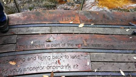
There is a fairly new viewing platform here, with a nice bench to sit on and some thoughtful messages for modern visitors to ponder.
Bob told us about the rural road house numbering system, which told us that the house across the road, numbered 111, meant that we were 1.11 km from the junction with the main road. What a practical idea. It wasn't long before the ambulance arrived, and James was being quizzed and checked out by the experts. He was taken off to the Royal, with Philip in attendance in the ambulance and Kat bringing up the rear.
The remaining four of us decided that we needed a soothing, simple walk to calm us down! Robert suggested St Crispin's Well, which was fairly close, so we headed back up Huon Rd and parked at the watertank near the Morphetts Rd turnoff. We started walking at last at about 10.30am, leaving our boots and walking poles in the car.
The Pipeline Track is a level and well compacted dirt road, basically a firetrail. It is very easy walking, and is very popular with bike riders and runners. It was a fine, overcast and cool day, and the riders and runners were thoroughly enjoying the track.
After about an hour and 15 minutes of walking, there was an extension of the potato fields reaching down to the Pipeline Track:
Not long after this, we found the clearly marked track to St Crispin's Well.
Just at this point on the Pipeline Track there is an emergency shelter, well stocked with firewood in case of being snowed in.
There is a fairly new viewing platform here, with a nice bench to sit on and some thoughtful messages for modern visitors to ponder.
We enjoyed a quick lunch and then got back on the trail before we cooled down too much. Meandering pleasantly back along the Pipeline Track, we couldn't help but notice Cathedral Rock across the valley, looking very grand (and high and craggy). All of us (except Lyn, who is very fit) agreed we had in fact been very lucky to not do that walk. We got back to our cars at 1.30pm.
Back in town we caught up with Kat over a cuppa at Pilgrim Coffee, to hear how the injured James was doing. Thankfully all seemed to be well.
Subscribe to:
Posts (Atom)